
File:Campaign of the Battle of Ain Jalut 1260.svg

Size of this PNG preview of this SVG file: 432 × 572 pixels. Waxyaabaha kale xalinta: 181 × 240 pixels | 362 × 480 pixels | 580 × 768 pixels | 773 × 1,024 pixels | 1,547 × 2,048 pixels.
Faylka asalka ah (SVG file, nominally 432 × 572 pixels, file size: 146 KB)
Qoraal kooban
| Sharaxaad |
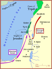
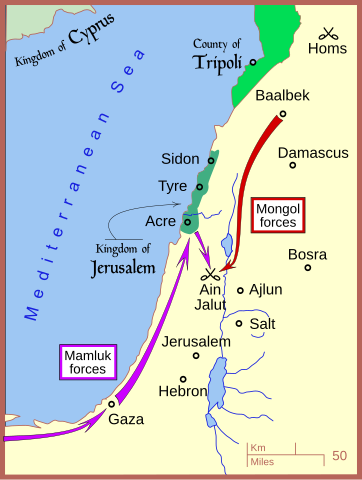
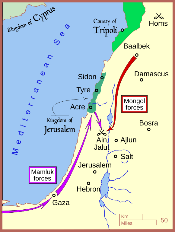
English: A map of the campaign leading to the Battle of Ain Jalut — in 1260 CE. |
| Taariikhda | |
| Xigasho | Shaqadayda |
| Qoraa | MapMaster |
| Other versions |
[]
|


|
This SVG file contains embedded text that can be translated into your language, using any capable SVG editor, text editor or the SVG Translate tool. For more information see: About translating SVG files. |
References
- Amitai-Preiss, Reuven (1995) Mongols and Mamluks: The Mamluk-Ilkhanid War, 1260-1281, Cambridge University Press, Cambridge ISBN: 978-0521462266.
- Tschanz, David W. (July/August 2007). "History's Hinge: 'Ain Jalut". Saudi Aramco World. Retrieved on 2007-09-24.
The borders of the rump Kingdom of Jerusalem and the County of Tripoli are based on:
- Sheperd, William R. (1911) "Mediterranean Lands after 1204", in Historical Atlas, New York: Henry Holt and Company, p. 73.
Laysinka
I, the copyright holder of this work, hereby publish it under the following license:
This file is licensed under the Creative Commons Attribution 3.0 Unported license.
- Waad fasaxantahay:
- la wadaagid – koobi gareenta, qaybinta iyo gudbinta shaqada
- to remix – in shaqada la waafajiyo
- Shuruudaha soo socda:
- Astaan – You must give appropriate credit, provide a link to the license, and indicate if changes were made. You may do so in any reasonable manner, but not in any way that suggests the licensor endorses you or your use.
Taariikhda faylka
Riix taariikhda/waqtiga si aad u argto faylka sida oo ahaa markiisa hore.
| Taariikhda/Waqtiga | Sawir yar | Cabirka | Isticmaale | Ka hadalka | |
|---|---|---|---|---|---|
| kan hadda | 19:01, 7 Luuliyo ama Luulyo 2008 | | 432 × 572 (146 KB) | MapMaster | adjusting colors |
| 04:53, 18 Juun 2008 |  | 432 × 572 (151 KB) | MapMaster | ||
| 16:22, 13 Juun 2008 |  | 432 × 572 (146 KB) | MapMaster | minor edits | |
| 11:33, 13 Juun 2008 |  | 434 × 574 (126 KB) | MapMaster | {{Information |Description={{en|1=A map of the campaign leading to the Battle of Ain Jalut, 1260.}} |Source=Own work by uploader |Author=MapMaster |Date=13 June 2008 |Permission= |other_versions= }} {{ImageUpload|full}} |
Faylka lagu isticmaalay
waxyaabaha soo socda ee bog ayaa adeegsanaya faylkaan:
isticmaalka faylka aduunka
Wikisyada kale ee soosocda ayaa adeegsanaya faylka:
- Ku isticmaal azb.wikipedia.org
- Ku isticmaal ba.wikipedia.org
- Ku isticmaal bg.wikipedia.org
- Ku isticmaal bn.wikipedia.org
- Ku isticmaal ca.wikipedia.org
- Ku isticmaal ckb.wikipedia.org
- Ku isticmaal cs.wikipedia.org
- Ku isticmaal de.wikipedia.org
- Ku isticmaal en.wikipedia.org
- Ku isticmaal es.wikipedia.org
- Ku isticmaal et.wikipedia.org
- Ku isticmaal fr.wikipedia.org
- Ku isticmaal he.wikipedia.org
- Ku isticmaal hr.wikipedia.org
- Ku isticmaal id.wikipedia.org
- Ku isticmaal ja.wikipedia.org
- Ku isticmaal ko.wikipedia.org
- Ku isticmaal lt.wikipedia.org
- Ku isticmaal ml.wikipedia.org
- Ku isticmaal nl.wikipedia.org
- Ku isticmaal no.wikipedia.org
- Ku isticmaal pl.wikipedia.org
- Ku isticmaal pnb.wikipedia.org
- Ku isticmaal ru.wikipedia.org
- Ku isticmaal sl.wikipedia.org
- Ku isticmaal sr.wikipedia.org
- Ku isticmaal su.wikipedia.org
- Ku isticmaal sv.wikipedia.org
- Ku isticmaal th.wikipedia.org
- Ku isticmaal tr.wikipedia.org
- Ku isticmaal ug.wikipedia.org
- Ku isticmaal uk.wikipedia.org
- Ku isticmaal ur.wikipedia.org
- Ku isticmaal uz.wikipedia.org
- Ku isticmaal www.wikidata.org
- Ku isticmaal zh.wikipedia.org