
File:Ke-map.png
Faah faahin dheeraad ah malahan.
Ke-map.png (325 × 349 pixels, weyninka faylka : 16 KB, nuuca MIME: image/png)
Qoraal kooban
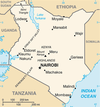
| Sharaxaad | Kenya map from CIA World Factbook, converted from original GIF format (July 2011 version showing South Sudan) |
| Taariikhda | |
| Xigasho |
CIA World Factbook |
| Qoraa | United States Central Intelligence Agency |
| Other versions |
|
.png)
Laysinka
This image is in the public domain because it contains materials that originally came from the United States Central Intelligence Agency's World Factbook.
|
 |
Taariikhda faylka
Riix taariikhda/waqtiga si aad u argto faylka sida oo ahaa markiisa hore.
| Taariikhda/Waqtiga | Sawir yar | Cabirka | Isticmaale | Ka hadalka | |
|---|---|---|---|---|---|
| kan hadda | 04:58, 12 Febraayo 2022 | | 325 × 349 (16 KB) | Lojwe | Cropped 1 % horizontally, 1 % vertically using CropTool with precise mode. |
| 00:04, 13 Luuliyo ama Luulyo 2011 |  | 329 × 354 (47 KB) | Béka~commonswiki | new version with South Sudan, from CIA | |
| 20:12, 5 Maaj 2005 |  | 330 × 353 (10 KB) | Alfio | CIA map of Kenya |
Faylka lagu isticmaalay
Ma jiraan bogag adeegsanaya faylkaan.
isticmaalka faylka aduunka
Wikisyada kale ee soosocda ayaa adeegsanaya faylka:
- Ku isticmaal bn.wikipedia.org
- Ku isticmaal ca.wikipedia.org
- Ku isticmaal da.wikipedia.org
- Ku isticmaal de.wikipedia.org
- Ku isticmaal de.wikinews.org
- Ku isticmaal dsb.wikipedia.org
- Ku isticmaal en.wikipedia.org
- Ku isticmaal en.wikinews.org
- Ku isticmaal eo.wikipedia.org
- Ku isticmaal es.wikipedia.org
- Ku isticmaal fa.wikipedia.org
- Ku isticmaal fi.wikipedia.org
- Ku isticmaal fo.wikipedia.org
- Ku isticmaal fr.wikipedia.org
- Ku isticmaal gom.wikipedia.org
- Ku isticmaal he.wikipedia.org
- Ku isticmaal hi.wikipedia.org
- Ku isticmaal hu.wikipedia.org
- Ku isticmaal ilo.wikipedia.org
- Ku isticmaal io.wikipedia.org
- Ku isticmaal it.wikipedia.org
- Ku isticmaal it.wikinews.org
- Ku isticmaal ja.wikipedia.org
- Ku isticmaal ka.wikipedia.org
- Ku isticmaal kn.wikipedia.org
- Ku isticmaal ml.wikipedia.org
- Ku isticmaal mr.wikipedia.org
- Ku isticmaal nn.wikipedia.org
View more global usage of this file.