
File:Somalia Numbered Regions.png
Cabirka muuqaalkaan: 480 × 600 pixels. Waxyaabaha kale xalinta: 192 × 240 pixels | 512 × 640 pixels.
Faylka asalka ah (512 × 640 pixels, weyninka faylka : 20 KB, nuuca MIME: image/png)
| Sharaxaad |
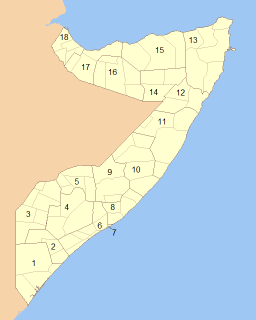
English: Blank map of Somalia showing the regions (numbered) and districts in detail together. 1- Lower Juba 2- Middle Juba 3- Gedo 4- Bay 5- Bakool 6- Lower Shabele 7- Banaadir 8- Middle Shabele 9- Hiiraan 10- Galguduud 11- Mudug 12- Nugaal 13- Bari 14- Sool 15- Sanaag 16- Togdheer 17- Woqooyi Galbeed 18- Awdal |
||
| Taariikhda | |||
| Xigasho | Modified File:Somalia Regions and Districts.png to create image | ||
| Qoraa | Wiz9999 | ||
| Ogolaasho (Dib u isticmaalka faylkaan) |
|
||
| Other versions | File:Somalia Regions and Districts.png |
Taariikhda faylka
Riix taariikhda/waqtiga si aad u argto faylka sida oo ahaa markiisa hore.
| Taariikhda/Waqtiga | Sawir yar | Cabirka | Isticmaale | Ka hadalka | |
|---|---|---|---|---|---|
| kan hadda | 00:13, 6 Juun 2009 | | 512 × 640 (20 KB) | Wiz9999 | {{Information |Description={{en|1=Blank map of Somalia showing the regions (numbered) and districts in detail together.}} |Source=Modified File:Somalia Regions and Districts.png to create image |Author=Wiz9999 |Date=2009-06-05 |Permi |
Faylka lagu isticmaalay
waxyaabaha soo socda ee 4 boggag ayaa isticmaalaya faylkaan:
isticmaalka faylka aduunka
Wikisyada kale ee soosocda ayaa adeegsanaya faylka:
- Ku isticmaal als.wikipedia.org
- Ku isticmaal ar.wikipedia.org
- Ku isticmaal azb.wikipedia.org
- Ku isticmaal bg.wikipedia.org
- Ku isticmaal bs.wikipedia.org
- Ku isticmaal da.wikipedia.org
- Ku isticmaal de.wikipedia.org
- Ku isticmaal el.wikipedia.org
- Ku isticmaal en.wikipedia.org
- Ku isticmaal es.wikipedia.org
- Ku isticmaal eu.wikipedia.org
- Ku isticmaal fa.wikipedia.org
- Ku isticmaal is.wikipedia.org
- Ku isticmaal it.wikipedia.org
- Ku isticmaal ko.wikipedia.org
- Ku isticmaal li.wikipedia.org
- Ku isticmaal mk.wikipedia.org
- Ku isticmaal mzn.wikipedia.org
- Ku isticmaal no.wikipedia.org
- Ku isticmaal pl.wikipedia.org
- Ku isticmaal ps.wikipedia.org
- Ku isticmaal pt.wikipedia.org
- Ku isticmaal ro.wikipedia.org
- Ku isticmaal ru.wikipedia.org
- Ku isticmaal trv.wikipedia.org
- Ku isticmaal tr.wikipedia.org
- Ku isticmaal ur.wikipedia.org
- Ku isticmaal zh-classical.wikipedia.org
- Ku isticmaal zh.wikipedia.org