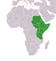
File:Africa-countries-CECAFA.png
Africa-countries-CECAFA.png (360 × 392 pixels, weyninka faylka : 14 KB, nuuca MIME: image/png)
Taariikhda faylka
Riix taariikhda/waqtiga si aad u argto faylka sida oo ahaa markiisa hore.
| Taariikhda/Waqtiga | Sawir yar | Cabirka | Isticmaale | Ka hadalka | |
|---|---|---|---|---|---|
| kan hadda | 16:53, 27 Maaj 2016 |  | 360 × 392 (14 KB) | Christian Ferrer | Reverted to version as of 08:55, 26 March 2016 (UTC) |
| 15:36, 27 Maaj 2016 |  | 360 × 392 (13 KB) | Insidema | Reverted to version as of 16:35, 25 March 2016 (UTC) | |
| 08:55, 26 Maaj 2016 |  | 360 × 392 (14 KB) | Ankry | Reverted to version as of 18:53, 9 July 2011 (UTC) | |
| 16:35, 25 Maaj 2016 |  | 360 × 392 (13 KB) | Hpyounes | update | |
| 18:53, 9 Luuliyo ama Luulyo 2011 |  | 360 × 392 (14 KB) | Maphobbyist | South Sudan has become independent on July 9, 2011. Sudan and South Sudan are shown with the new international border between them. | |
| 21:36, 24 Oktoobar 2010 |  | 360 × 392 (10 KB) | Alletto | {{Information |Description={{de|Karte Mitgliedstaaten des de:Council for East and Central Africa Football Association}} |Source=Transferred from [http://de.wikipedia.org de.wikipedia]<br/> (Original text : ''Eigenarbeit'') |Date=26. April 2010<br/> |
Faylka lagu isticmaalay
waxyaabaha soo socda ee bog ayaa adeegsanaya faylkaan:
isticmaalka faylka aduunka
Wikisyada kale ee soosocda ayaa adeegsanaya faylka:
- Ku isticmaal ar.wikipedia.org
- Ku isticmaal bn.wikipedia.org
- Ku isticmaal ca.wikipedia.org
- Ku isticmaal de.wikipedia.org
- Ku isticmaal en.wikipedia.org
- Ku isticmaal es.wikipedia.org
- Ku isticmaal fr.wikipedia.org
- Ku isticmaal hu.wikipedia.org
- Ku isticmaal id.wikipedia.org
- Ku isticmaal ko.wikipedia.org
- Ku isticmaal sk.wikipedia.org
- Ku isticmaal sv.wikipedia.org
- Ku isticmaal uk.wikipedia.org
- Ku isticmaal www.wikidata.org

