
File:Arabia 1914.png
Cabirka muuqaalkaan: 713 × 600 pixels. Waxyaabaha kale xalinta: 285 × 240 pixels | 571 × 480 pixels | 976 × 821 pixels.
Faylka asalka ah (976 × 821 pixels, weyninka faylka : 111 KB, nuuca MIME: image/png)
Qoraal kooban
| Sharaxaad |
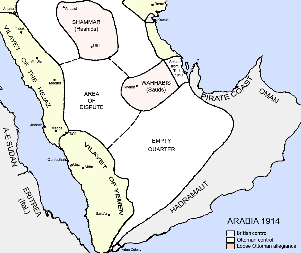
English: Political borders of the Arabian Peninsula in 1914. Source: Collapse of Empire: Ottoman Turks and the Arabs in the First World War, itself from King Husain and the Kingdom of Hejaz By Randall Baker . |
| Taariikhda | |
| Xigasho | Shaqadayda |
| Qoraa | Underlying lk |
| Other versions |
.png) .png)  |

|
This historical map image could be re-created using vector graphics as an SVG file. This has several advantages; see Commons:Media for cleanup for more information. If an SVG form of this image is available, please upload it and afterwards replace this template with
{{vector version available|new image name}}.
It is recommended to name the SVG file “Arabia 1914.svg”—then the template Vector version available (or Vva) does not need the new image name parameter. |
Laysinka
I, the copyright holder of this work, hereby publish it under the following license:
This file is licensed under the Creative Commons Attribution-Share Alike 3.0 Unported license.
- Waad fasaxantahay:
- la wadaagid – koobi gareenta, qaybinta iyo gudbinta shaqada
- to remix – in shaqada la waafajiyo
- Shuruudaha soo socda:
- Astaan – You must give appropriate credit, provide a link to the license, and indicate if changes were made. You may do so in any reasonable manner, but not in any way that suggests the licensor endorses you or your use.
- si isku mid la wadaag – If you remix, transform, or build upon the material, you must distribute your contributions under the same or compatible license as the original.
Taariikhda faylka
Riix taariikhda/waqtiga si aad u argto faylka sida oo ahaa markiisa hore.
| Taariikhda/Waqtiga | Sawir yar | Cabirka | Isticmaale | Ka hadalka | |
|---|---|---|---|---|---|
| kan hadda | 04:34, 26 Febraayo 2024 | | 976 × 821 (111 KB) | Abo Yemen | fixed map legend as it used to cause confusion that the region in grey is hadhramout |
| 09:52, 22 Mey 2013 |  | 976 × 821 (154 KB) | Underlying lk | User created page with UploadWizard |
Faylka lagu isticmaalay
Ma jiraan bogag adeegsanaya faylkaan.
isticmaalka faylka aduunka
Wikisyada kale ee soosocda ayaa adeegsanaya faylka:
- Ku isticmaal ar.wikipedia.org
- Ku isticmaal azb.wikipedia.org
- Ku isticmaal az.wikipedia.org
- Ku isticmaal bn.wikipedia.org
- Ku isticmaal cs.wikipedia.org
- Ku isticmaal da.wikipedia.org
- Ku isticmaal de.wikipedia.org
- Ku isticmaal en.wikipedia.org
- Ku isticmaal fr.wikipedia.org
- Ku isticmaal gl.wikipedia.org
- Ku isticmaal gom.wikipedia.org
- Ku isticmaal he.wikipedia.org
- Ku isticmaal hu.wikipedia.org
- Ku isticmaal hy.wikipedia.org
- Ku isticmaal id.wikipedia.org
- Ku isticmaal it.wikipedia.org
- Ku isticmaal ja.wikipedia.org
View more global usage of this file.