
File:Armenia - Location Map (2013) - ARM - UNOCHA.svg

Faylka asalka ah (SVG file, nominally 250 × 250 pixels, file size: 713 KB)
_-_ARM_-_UNOCHA.svg)
Qoraal kooban
| Sharaxaad |
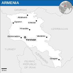
English: Locator map of Armenia. |
| Taariikhda | |
| Xigasho |
English: Armenia Locator Map (ReliefWeb), ESRI, UNCS |
| Qoraa | |
| SVG genesis |
Laysinka
- Waad fasaxantahay:
- la wadaagid – koobi gareenta, qaybinta iyo gudbinta shaqada
- to remix – in shaqada la waafajiyo
- Shuruudaha soo socda:
- Astaan – You must give appropriate credit, provide a link to the license, and indicate if changes were made. You may do so in any reasonable manner, but not in any way that suggests the licensor endorses you or your use.
 This map is part of a collection of 216 free country maps, created by the UN Office for the Coordination of Humanitarian Affairs (OCHA), to be used in print, web or broadcast products.
The ReliefWeb Location Maps released here are maps that highlight a country, its capital, major populated places and the surrounding regions. Attribution Requirements
Using the map without modifications: ensure that the sources and the disclaimer are below the map. Credit as follows: "Credit: OCHA". For use with alteration: remove the OCHA logo and disclaimer following any modification to the map, but keep the data sources as mentioned below the map. Credit the modified map as follows: "Based on OCHA map". You are responsible for the content of your map. We are keen to receive your feedback and hear how you used OCHA's maps. We would be grateful if you would notify us by e-mail and share your work with us. UN Disclaimer
The designations employed and the presentation of material of this map do not imply the expression of any opinion whatsoever on the part of the Secretariat of the United Nations concerning the legal status of any country, territory, city or area or of its authorities or concerning the delimitation of its frontiers or boundaries. |

|
Textual information (e.g. timestamp) once visible in the image itself has been moved into the image metadata and/or image description page. This makes the image easier to reuse and more language-neutral, and makes the text easier to process and search for. Commons discourages placing visible textual information in images. All licenses accepted on Commons permit this type of modification as a derivative work.
If attribution information were removed and the image is not public domain, replace this tag with {{Attribution metadata from licensed image}}.
|
Taariikhda faylka
Riix taariikhda/waqtiga si aad u argto faylka sida oo ahaa markiisa hore.
| Taariikhda/Waqtiga | Sawir yar | Cabirka | Isticmaale | Ka hadalka | |
|---|---|---|---|---|---|
| kan hadda | 01:50, 23 Diseembar 2022 | | 250 × 250 (713 KB) | Wikijahnn | File uploaded using svgtranslate tool (https://svgtranslate.toolforge.org/). Added translation for ca. |
| 13:34, 9 Maaj 2022 |  | 250 × 250 (711 KB) | Nyilvoskt | File uploaded using svgtranslate tool (https://svgtranslate.toolforge.org/). Added translation for id. | |
| 20:43, 5 Jannaayo 2016 |  | 250 × 250 (709 KB) | Wereldburger758 | Resized page to drawing. Removal watermark. Validation of image. | |
| 20:46, 24 Febraayo 2014 |  | 254 × 254 (715 KB) | Jeremyb | xslt v2b | |
| 20:41, 10 Febraayo 2014 |  | 250 × 250 (1.73 MB) | Pharos | {{Information |description={{en|1=Locator Map of Armenia. {{OCHA map}}}} |date=February 2014 |source=UN Office for the Coordination of Humanitarian Affairs (OCHA) |author=[[w:Unit... |
Faylka lagu isticmaalay
waxyaabaha soo socda ee bog ayaa adeegsanaya faylkaan:
isticmaalka faylka aduunka
Wikisyada kale ee soosocda ayaa adeegsanaya faylka:
- Ku isticmaal az.wikipedia.org
- Ku isticmaal ca.wikipedia.org
- Ku isticmaal en.wikipedia.org
- Ku isticmaal es.wikipedia.org
- Ku isticmaal fr.wikipedia.org
- Ku isticmaal gor.wikipedia.org
- Ku isticmaal id.wikipedia.org
- Ku isticmaal ru.wikipedia.org
- Ku isticmaal sat.wikipedia.org
- Ku isticmaal ts.wikipedia.org
- Ku isticmaal uk.wikipedia.org
_-_ARM_-_UNOCHA.svg)