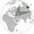
File:Azerbaijan with Nagorno Karabakh region.svg

Size of this PNG preview of this SVG file: 600 × 600 pixels. Waxyaabaha kale xalinta: 240 × 240 pixels | 480 × 480 pixels | 768 × 768 pixels | 1,024 × 1,024 pixels | 2,048 × 2,048 pixels | 689 × 689 pixels.
Faylka asalka ah (SVG file, nominally 689 × 689 pixels, file size: 578 KB)
Taariikhda faylka
Riix taariikhda/waqtiga si aad u argto faylka sida oo ahaa markiisa hore.
| Taariikhda/Waqtiga | Sawir yar | Cabirka | Isticmaale | Ka hadalka | |
|---|---|---|---|---|---|
| kan hadda | 08:49, 24 Nofeembar 2020 |  | 689 × 689 (578 KB) | Golden | add a white dotted border around NKR |
| 08:46, 24 Nofeembar 2020 |  | 689 × 689 (578 KB) | Golden | Fix the borders of other countries; add more detail to new NKR | |
| 17:23, 15 Nofeembar 2020 |  | 551 × 551 (462 KB) | RufinaFridwald | Updating Karabagh related maps | |
| 12:40, 10 Nofeembar 2020 |  | 551 × 551 (421 KB) | Ratherous | Reverted to version as of 14:32, 4 November 2020 (UTC) User blocked. Wait on the change until boundaries are clear | |
| 14:11, 5 Nofeembar 2020 |  | 551 × 551 (462 KB) | CastorAeolus | Reverted to version as of 11:34, 27 October 2020 (UTC) No I won't. | |
| 14:32, 4 Nofeembar 2020 |  | 551 × 551 (421 KB) | MrLune | Reverted to version as of 18:00, 13 December 2019 (UTC) Wait the war end for map edit | |
| 11:34, 27 Oktoobar 2020 |  | 551 × 551 (462 KB) | CastorAeolus | Update | |
| 18:00, 13 Diseembar 2019 |  | 551 × 551 (421 KB) | Goran tek-en | Added border for South Sudan as requested by {{u|Maphobbyist}} | |
| 08:04, 27 Abriil 2012 |  | 551 × 551 (571 KB) | Interfase | {{Information |Description ={{en|1=Map of Azerbaijan (with Nagorno-Karabakh region) on the map of the world.}} |Source =Self-made from Azerbaijan (orthographic projection).svg |Author ... |
Faylka lagu isticmaalay
Ma jiraan bogag adeegsanaya faylkaan.
isticmaalka faylka aduunka
Wikisyada kale ee soosocda ayaa adeegsanaya faylka:
- Ku isticmaal az.wikipedia.org
- Ku isticmaal en.wikipedia.org
- Ku isticmaal fr.wikipedia.org
- Ku isticmaal ru.wikipedia.org
- Ku isticmaal www.wikidata.org
- Ku isticmaal zh.wikipedia.org
