
File:Biafra independent state map-en.svg

Size of this PNG preview of this SVG file: 776 × 600 pixels. Waxyaabaha kale xalinta: 311 × 240 pixels | 621 × 480 pixels | 994 × 768 pixels | 1,280 × 989 pixels | 2,560 × 1,978 pixels | 1,100 × 850 pixels.
Faylka asalka ah (SVG file, nominally 1,100 × 850 pixels, file size: 472 KB)

|
This SVG file contains embedded text that can be translated into your language, using any capable SVG editor, text editor or the SVG Translate tool. For more information see: About translating SVG files. |
Qoraal kooban
| Sharaxaad |
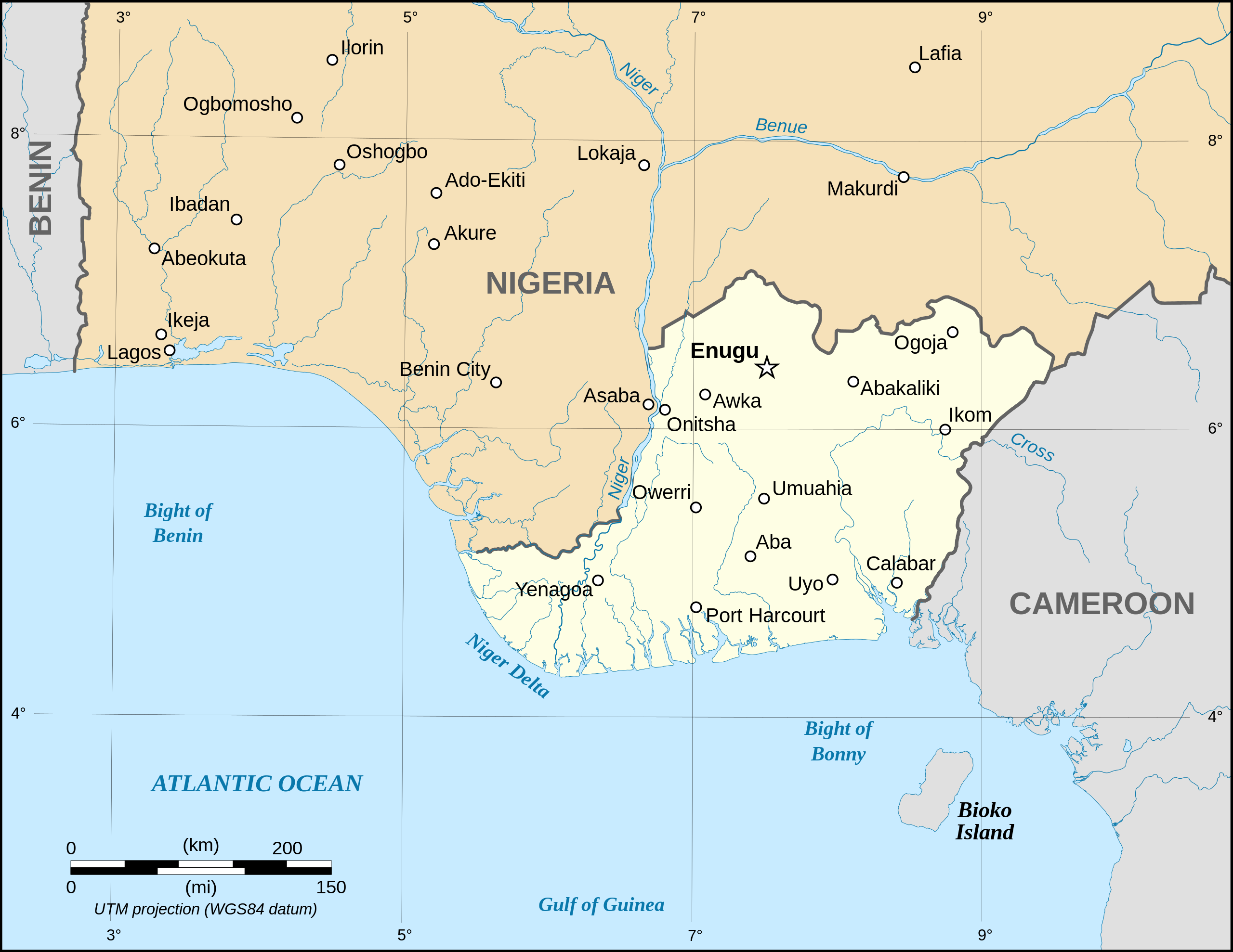
Català: Mapa de la república de Biafra en el maig 1967. English: Map of the secessionist state of the Republic of Biafra (1967 – 1970) as in May 1967. Note: The western boundary may not be accurate due to the low precision of the reference maps used which are also contradictory. Français : Carte en anglais de l'État sécessionniste de la République du Biafra (1967 – 1970) telle qu'en mai 1967. Note : La frontière Ouest peut ne pas être précise en raison de l'imprécision des cartes de référence qui sont aussi contradictoires. UTM projection ; WGS 84 datum |
||
| Taariikhda | September 2008 (new version) | ||
| Xigasho |
Own work
|
||
| Qoraa | Eric Gaba (Sting - fr:Sting) | ||
| Ogolaasho (Dib u isticmaalka faylkaan) |
|
||
| Other versions |
[]
|


|
|
This SVG file contains embedded text that can be translated into your language, using any capable SVG editor, text editor or the SVG Translate tool. For more information see: About translating SVG files. |
Laysinka
I, the copyright holder of this work, hereby publish it under the following licenses:

|
Permission is granted to copy, distribute and/or modify this document under the terms of the GNU Free Documentation License, Version 1.2 or any later version published by the Free Software Foundation; with no Invariant Sections, no Front-Cover Texts, and no Back-Cover Texts. A copy of the license is included in the section entitled GNU Free Documentation License. |
| This file is licensed under the Creative Commons Attribution-Share Alike 3.0 Unported license. | ||
| ||
| This licensing tag was added to this file as part of the GFDL licensing update. |
This file is licensed under the Creative Commons Attribution-Share Alike 2.5 Generic, 2.0 Generic and 1.0 Generic license.
- Waad fasaxantahay:
- la wadaagid – koobi gareenta, qaybinta iyo gudbinta shaqada
- to remix – in shaqada la waafajiyo
- Shuruudaha soo socda:
- Astaan – You must give appropriate credit, provide a link to the license, and indicate if changes were made. You may do so in any reasonable manner, but not in any way that suggests the licensor endorses you or your use.
- si isku mid la wadaag – If you remix, transform, or build upon the material, you must distribute your contributions under the same or compatible license as the original.
You may select the license of your choice.
Taariikhda faylka
Riix taariikhda/waqtiga si aad u argto faylka sida oo ahaa markiisa hore.
| Taariikhda/Waqtiga | Sawir yar | Cabirka | Isticmaale | Ka hadalka | |
|---|---|---|---|---|---|
| kan hadda | 19:21, 15 Sebteembar 2023 | | 1,100 × 850 (472 KB) | Glrx | 256 kB workaround // Editing SVG source code using c:User:Rillke/SVGedit.js |
| 10:59, 15 Sebteembar 2023 |  | 1,100 × 850 (472 KB) | KajenCAT | File uploaded using svgtranslate tool (https://svgtranslate.toolforge.org/). Added translation for ca. | |
| 04:51, 3 Sebteembar 2008 |  | 1,100 × 850 (455 KB) | Sting | New version using the NGDC GSHHS and WDBII data ; new standard colors | |
| 17:54, 12 Diseembar 2006 |  | 1,100 × 850 (163 KB) | Sting | {{Information| |Description=Map of the secessionist state of the Republic of Biafra (1967 – 1970) |Source=Own work<br/>Background reference map : Microsoft Encarta atlas (1999 edition)<br/>Biafra independent state borders reference maps : [http://www.bi |
Faylka lagu isticmaalay
Ma jiraan bogag adeegsanaya faylkaan.
isticmaalka faylka aduunka
Wikisyada kale ee soosocda ayaa adeegsanaya faylka:
- Ku isticmaal af.wikipedia.org
- Ku isticmaal ar.wikipedia.org
- Ku isticmaal ast.wikipedia.org
- Ku isticmaal azb.wikipedia.org
- Ku isticmaal be.wikipedia.org
- Ku isticmaal bn.wikipedia.org
- Ku isticmaal br.wikipedia.org
- Ku isticmaal ca.wikipedia.org
- Ku isticmaal cs.wikipedia.org
- Ku isticmaal da.wikipedia.org
- Ku isticmaal el.wikipedia.org
- Ku isticmaal en.wikipedia.org
- Ku isticmaal eo.wikipedia.org
- Ku isticmaal es.wikipedia.org
- Ku isticmaal et.wikipedia.org
- Ku isticmaal eu.wikipedia.org
- Ku isticmaal fa.wikipedia.org
- Ku isticmaal gl.wikipedia.org
- Ku isticmaal ha.wikipedia.org
- Ku isticmaal he.wikipedia.org
- Ku isticmaal hu.wikipedia.org
- Ku isticmaal hy.wikipedia.org
- Ku isticmaal id.wikipedia.org
- Ku isticmaal ig.wikipedia.org
- Ku isticmaal io.wikipedia.org
- Ku isticmaal is.wikipedia.org
- Ku isticmaal ja.wikipedia.org
View more global usage of this file.