
File:Ilemi triangle map.PNG

Cabirka muuqaalkaan: 800 × 592 pixels. Waxyaabaha kale xalinta: 320 × 237 pixels | 640 × 473 pixels | 990 × 732 pixels.
Faylka asalka ah (990 × 732 pixels, weyninka faylka : 85 KB, nuuca MIME: image/png)
Qoraal kooban
| Sharaxaad |
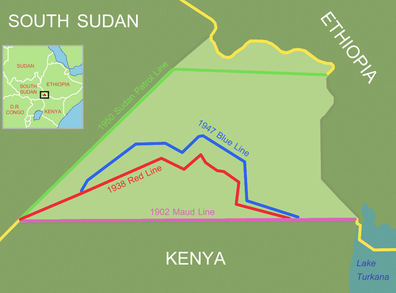
Ilemi triangle (light area), disputed area between Ethiopia, Sudan and Kenya
Reference and further information: DELIMITATION OF THE ELASTIC ILEMI TRIANGLE: PASTORAL CONFLICTS AND OFFICIAL INDIFFERENCE IN THE HORN OF AFRICA See also: satellite image |
| Taariikhda | 24 Maaj 2006 (original upload date) |
| Xigasho | No machine-readable source provided. Own work assumed (based on copyright claims). |
| Qoraa | No machine-readable author provided. Roke~commonswiki assumed (based on copyright claims). |
Laysinka
I, the copyright holder of this work, hereby publish it under the following license:

|
Permission is granted to copy, distribute and/or modify this document under the terms of the GNU Free Documentation License, Version 1.2 or any later version published by the Free Software Foundation; with no Invariant Sections, no Front-Cover Texts, and no Back-Cover Texts. A copy of the license is included in the section entitled GNU Free Documentation License. |
| This file is licensed under the Creative Commons Attribution-Share Alike 3.0 Unported license. | ||
| ||
| This licensing tag was added to this file as part of the GFDL licensing update. |
Taariikhda faylka
Riix taariikhda/waqtiga si aad u argto faylka sida oo ahaa markiisa hore.
| Taariikhda/Waqtiga | Sawir yar | Cabirka | Isticmaale | Ka hadalka | |
|---|---|---|---|---|---|
| kan hadda | 14:00, 9 Luuliyo ama Luulyo 2011 | | 990 × 732 (85 KB) | Nicolay Sidorov | + South Sudan |
| 12:43, 19 Juun 2006 |  | 990 × 732 (118 KB) | Roke~commonswiki | try again, something wrong with thumbnail on WP | |
| 11:59, 14 Juun 2006 |  | 990 × 732 (451 KB) | Roke~commonswiki | Reverted to earlier revision | |
| 11:58, 14 Juun 2006 |  | 990 × 732 (46 KB) | Roke~commonswiki | version without satellite, less confusing | |
| 02:46, 24 Maaj 2006 |  | 990 × 732 (451 KB) | Roke~commonswiki | Ilemi triangle, disputed area between Ethiopia, Sudan and Kenya The satellite image was a Public domain image from NASA World Wind, the other information was added with Corel Painter IX Category: Kenya Category: Ethiopia Category: Sudan |
Faylka lagu isticmaalay
waxyaabaha soo socda ee bog ayaa adeegsanaya faylkaan:
isticmaalka faylka aduunka
Wikisyada kale ee soosocda ayaa adeegsanaya faylka:
- Ku isticmaal be.wikipedia.org
- Ku isticmaal ca.wikipedia.org
- Ku isticmaal cs.wikipedia.org
- Ku isticmaal de.wikipedia.org
- Ku isticmaal en.wikipedia.org
- Ku isticmaal es.wikipedia.org
- Ku isticmaal fr.wikipedia.org
- Ku isticmaal hi.wikipedia.org
- Ku isticmaal hr.wikipedia.org
- Ku isticmaal id.wikipedia.org
- Ku isticmaal it.wikipedia.org
- Ku isticmaal ja.wikipedia.org
- Ku isticmaal ka.wikipedia.org
- Ku isticmaal ko.wikipedia.org
- Ku isticmaal lt.wikipedia.org
- Ku isticmaal nl.wikipedia.org
- Ku isticmaal no.wikipedia.org
- Ku isticmaal pl.wikipedia.org
- Ku isticmaal pt.wikipedia.org
- Ku isticmaal ru.wikipedia.org
- Ku isticmaal sr.wikipedia.org
- Ku isticmaal uk.wikipedia.org
- Ku isticmaal zh.wikipedia.org