
File:Indonesia provinces english.png

Cabirka muuqaalkaan: 800 × 365 pixels. Waxyaabaha kale xalinta: 320 × 146 pixels | 640 × 292 pixels | 1,628 × 742 pixels.
Faylka asalka ah (1,628 × 742 pixels, weyninka faylka : 92 KB, nuuca MIME: image/png)

|
File:Indonesia, administrative divisions - en - monochrome.svg is a vector version of this file. It should be used in place of this PNG file when not inferior.
File:Indonesia provinces english.png → File:Indonesia, administrative divisions - en - monochrome.svg
For more information, see Help:SVG. |
 |

|
This file requires updating because: In 2022, the Papua provinces changed from 2 provinces to 6 provinces. In doing so, you could add a timestamp to the file.
|
Qoraal kooban
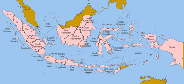
Map of the provinces of Indonesia in English.
Made by User:Golbez based on a PD CIA map, using other sources to guesstimate the extent of West Irian Jaya and West Sulawesi.
derivative works
Derivative works of this file: Indonesia, administrative divisions - en - monochrome.svg
Laysinka
I, the copyright holder of this work, hereby publish it under the following licenses:

|
Permission is granted to copy, distribute and/or modify this document under the terms of the GNU Free Documentation License, Version 1.2 or any later version published by the Free Software Foundation; with no Invariant Sections, no Front-Cover Texts, and no Back-Cover Texts. A copy of the license is included in the section entitled GNU Free Documentation License. |
| This file is licensed under the Creative Commons Attribution-Share Alike 3.0 Unported license. | ||
| ||
| This licensing tag was added to this file as part of the GFDL licensing update. |
This file is licensed under the Creative Commons Attribution 2.5 Generic license.
- Waad fasaxantahay:
- la wadaagid – koobi gareenta, qaybinta iyo gudbinta shaqada
- to remix – in shaqada la waafajiyo
- Shuruudaha soo socda:
- Astaan – You must give appropriate credit, provide a link to the license, and indicate if changes were made. You may do so in any reasonable manner, but not in any way that suggests the licensor endorses you or your use.
You may select the license of your choice.
Taariikhda faylka
Riix taariikhda/waqtiga si aad u argto faylka sida oo ahaa markiisa hore.
| Taariikhda/Waqtiga | Sawir yar | Cabirka | Isticmaale | Ka hadalka | |
|---|---|---|---|---|---|
| kan hadda | 12:40, 25 Oktoobar 2020 | | 1,628 × 742 (92 KB) | Afrogindahood | Addition of North Kalimantan province |
| 07:54, 8 Jannaayo 2006 | 1,500 × 590 (77 KB) | Golbez | Map of the provinces of Indonesian in English. Made by User:Golbez based on a PD CIA map, using other sources to guesstimate the extent of West Irian Jaya and West Sulawesi. Category:Maps of Indonesia |
Faylka lagu isticmaalay
waxyaabaha soo socda ee bog ayaa adeegsanaya faylkaan:
isticmaalka faylka aduunka
Wikisyada kale ee soosocda ayaa adeegsanaya faylka:
- Ku isticmaal arz.wikipedia.org
- Ku isticmaal ba.wikipedia.org
- Ku isticmaal be-tarask.wikipedia.org
- Ku isticmaal blk.wikipedia.org
- Ku isticmaal bxr.wikipedia.org
- Ku isticmaal ca.wikipedia.org
- Ku isticmaal ceb.wikipedia.org
- Ku isticmaal crh.wikipedia.org
- Ku isticmaal csb.wikipedia.org
- Ku isticmaal cs.wikipedia.org
- Ku isticmaal cy.wikipedia.org
- Ku isticmaal da.wikipedia.org
- Ku isticmaal diq.wikipedia.org
- Ku isticmaal dv.wikipedia.org
- Ku isticmaal en.wikipedia.org
- Ku isticmaal es.wikipedia.org
- Ku isticmaal fr.wikipedia.org
- Ku isticmaal gd.wikipedia.org
- Ku isticmaal gl.wikipedia.org
- Ku isticmaal ht.wikipedia.org
- Ku isticmaal hu.wikipedia.org
- Ku isticmaal incubator.wikimedia.org
- Ku isticmaal it.wikipedia.org
- Ku isticmaal ja.wikipedia.org
- Ku isticmaal kaa.wikipedia.org
- Ku isticmaal kk.wikipedia.org
- Ku isticmaal km.wikipedia.org
- Ku isticmaal kn.wikipedia.org
- Ku isticmaal kv.wikipedia.org
- Ku isticmaal kw.wikipedia.org
- Ku isticmaal lij.wikipedia.org
- Ku isticmaal lmo.wikipedia.org
- Ku isticmaal ln.wikipedia.org
- Ku isticmaal lv.wikipedia.org
- Ku isticmaal mg.wikipedia.org
- Ku isticmaal mhr.wikipedia.org
- Ku isticmaal ml.wikipedia.org
- Ku isticmaal mn.wikipedia.org
- Ku isticmaal my.wikipedia.org
- Ku isticmaal mzn.wikipedia.org
- Ku isticmaal new.wikipedia.org
- Ku isticmaal nl.wikipedia.org
- Ku isticmaal nn.wikipedia.org
- Ku isticmaal pag.wikipedia.org
- Ku isticmaal pam.wikipedia.org
- Ku isticmaal pap.wikipedia.org
- Ku isticmaal pms.wikipedia.org
- Ku isticmaal pnb.wikipedia.org
View more global usage of this file.