
File:Mongolia (orthographic projection).svg

Size of this PNG preview of this SVG file: 553 × 553 pixels. Waxyaabaha kale xalinta: 240 × 240 pixels | 480 × 480 pixels | 768 × 768 pixels | 1,024 × 1,024 pixels | 2,048 × 2,048 pixels.
Faylka asalka ah (SVG file, nominally 553 × 553 pixels, file size: 301 KB)
Qoraal kooban
| Sharaxaad |
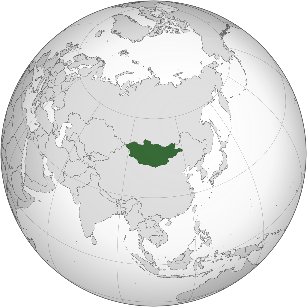
English: Orthographic Projection of Mongolia |
||
| Xigasho | Shaqadayda | ||
| Qoraa | ASDFGHJ | ||
| Other versions |
.svg)
|
.svg)
.svg)
.svg)
.svg)
.svg)
.svg)
.svg)
.svg)
.svg)
.svg)
.svg)
.svg)
.svg)
.svg)
.svg)
.svg)
.svg)
.svg)
.svg)
.svg)
.svg)
.svg)
.svg)
.svg)
.svg)
.svg)
.svg)
.svg)
.svg)
.svg)
.svg)
.svg)
.svg)
.svg)
.svg)
.svg)
.svg)
.svg)
.svg)
.svg)
.svg)
.svg)
.svg)
.svg)
.svg)
.svg)
.svg)
.svg)
.svg)
.svg)
.svg)
.svg)
.svg)
.svg)
.svg)
.svg)
.svg)
.svg)
.svg)
.svg)
.svg)
.svg)
.svg)
.svg)
.svg)
.svg)
.svg)
.svg)
.svg)
.svg)
.svg)
.svg)
.svg)

.svg)

.svg)

.svg)
.svg)
.svg)
.svg)
.svg)
.svg)
.svg)


.svg)
.svg)
.svg)
.svg)
.svg)
.svg)
.svg)

.svg)
.svg)
.svg)
.svg)
.svg)
.svg)
.svg)
.svg)
.svg)

.svg)
.svg)
.svg)
.svg)
.svg)
.svg)
.svg)
_without_national_boundaries.svg)
.svg)
.svg)
.svg)
.svg)
.svg)
.svg)

.svg)
.svg)
.png)
.svg)
.svg)
.svg)
.svg)

.svg)
.svg)
.svg)
.svg)
.svg)
.svg)
.svg)
.svg)
.svg)
.svg)
.svg)

.svg)
.svg)
.svg)
.svg)
.svg)
.svg)
.svg)
.svg)
.svg)

.svg)
.svg)

.svg)
.svg)
.svg)
.svg)
.svg)
.svg)
.svg)
.svg)
.svg)
.svg)
.svg)
.svg)
.svg)
.svg)
.svg)
.svg)
.svg)
.svg)
.svg)
.svg)
.svg)
.svg)
.svg)
.svg)
.svg)
.svg)
.svg)
_-_Crimea_disputed.svg)
.svg)
.svg)
.svg)
.svg)
.svg)
.svg)
.svg)
.svg)
.svg)
.svg)
.svg)
_political.svg)
.svg)
.svg)
.svg)
.svg)
_-_Crimea_disputed_-_no_borders.svg)
.svg)
.svg)
.svg)
.svg)
.svg)
.svg)
.svg)
.svg)
.svg)
.svg)
.svg)

.svg)
.svg)
.svg)

.png)
.svg)
.svg)
.svg)
.svg)
.svg)
.svg)
.svg)
.svg)
.svg)
.svg)
.svg)
.svg)
.svg)
.svg)
.svg)
.svg)
.svg)
.svg)
.svg)
.svg)
.svg)
.svg)
.svg)
.svg)
.svg)
.svg)
.svg)
.svg)
.svg)
.svg)
.svg)
.svg)
.svg)
.svg)
.png)
.svg)
.svg)
.svg)
_(orthographic_projection).png)
.svg)
.svg)
.svg)
Laysinka
I, the copyright holder of this work, hereby publish it under the following licenses:
This file is licensed under the Creative Commons Attribution-Share Alike 3.0 Unported license.
- Waad fasaxantahay:
- la wadaagid – koobi gareenta, qaybinta iyo gudbinta shaqada
- to remix – in shaqada la waafajiyo
- Shuruudaha soo socda:
- Astaan – You must give appropriate credit, provide a link to the license, and indicate if changes were made. You may do so in any reasonable manner, but not in any way that suggests the licensor endorses you or your use.
- si isku mid la wadaag – If you remix, transform, or build upon the material, you must distribute your contributions under the same or compatible license as the original.

|
Permission is granted to copy, distribute and/or modify this document under the terms of the GNU Free Documentation License, Version 1.2 or any later version published by the Free Software Foundation; with no Invariant Sections, no Front-Cover Texts, and no Back-Cover Texts. A copy of the license is included in the section entitled GNU Free Documentation License. |
You may select the license of your choice.
Taariikhda faylka
Riix taariikhda/waqtiga si aad u argto faylka sida oo ahaa markiisa hore.
| Taariikhda/Waqtiga | Sawir yar | Cabirka | Isticmaale | Ka hadalka | |
|---|---|---|---|---|---|
| kan hadda | 12:12, 22 Juun 2022 | | 553 × 553 (301 KB) | NexusKnots | Reverted to version as of 12:40, 4 August 2013 (UTC) Somaliland declared independence from Somalia in 1991 and Kosovo declared its independence on 17/2/2008. |
| 23:35, 16 Maaj 2015 |  | 553 × 553 (296 KB) | Flappiefh | Removed Somaliland and Kosovo. Separated Western Sahara and Morroco. | |
| 12:40, 4 Agoosto 2013 |  | 553 × 553 (301 KB) | Flappiefh | Added South Sudan. | |
| 05:30, 6 Luuliyo ama Luulyo 2009 |  | 541 × 541 (499 KB) | ASDFGHJ | == Summary == {{Information |Description={{en|1=Orthographic Projection of Mongolia}} |Source=Own work by uploader |Author=ASDFGHJ |Date= |Permission= |other_versions={{User:Ssolbergj/orthographic}} }} <!--{{ImageUpload|full}}--> == [[Co |
Faylka lagu isticmaalay
waxyaabaha soo socda ee 2 boggag ayaa isticmaalaya faylkaan:
isticmaalka faylka aduunka
Wikisyada kale ee soosocda ayaa adeegsanaya faylka:
- Ku isticmaal ady.wikipedia.org
- Ku isticmaal af.wikipedia.org
- Ku isticmaal ang.wikipedia.org
- Ku isticmaal ar.wikipedia.org
- منغوليا
- الجمهورية الشعبية المنغولية
- بوابة:منغوليا/واجهة
- بوابة:منغوليا
- قائمة الدول ذات السيادة والأقاليم التابعة في آسيا
- معاملة المثليين في منغوليا
- مستخدم:جار الله/قائمة صور مقالات العلاقات الثنائية
- العلاقات الأمريكية المنغولية
- العلاقات الأنغولية المنغولية
- العلاقات الكورية الجنوبية المنغولية
- العلاقات الإريترية المنغولية
- العلاقات السويسرية المنغولية
- العلاقات الألمانية المنغولية
- العلاقات الليختنشتانية المنغولية
- العلاقات البوليفية المنغولية
- العلاقات المنغولية الموزمبيقية
- العلاقات الألبانية المنغولية
- العلاقات البلجيكية المنغولية
- العلاقات الإثيوبية المنغولية
- العلاقات البيلاروسية المنغولية
- العلاقات الطاجيكستانية المنغولية
- العلاقات الرومانية المنغولية
- العلاقات الأرجنتينية المنغولية
- العلاقات الغامبية المنغولية
- العلاقات القبرصية المنغولية
- العلاقات السيراليونية المنغولية
- العلاقات المنغولية النيبالية
- العلاقات الليبيرية المنغولية
- العلاقات التشيكية المنغولية
- العلاقات المنغولية الميانمارية
- العلاقات العراقية المنغولية
- العلاقات البريطانية المنغولية
- العلاقات الكندية المنغولية
- العلاقات الكوبية المنغولية
- العلاقات الكورية الشمالية المنغولية
- العلاقات الكوستاريكية المنغولية
- العلاقات الكولومبية المنغولية
- العلاقات الكيريباتية المنغولية
- العلاقات الكينية المنغولية
- العلاقات اللاتفية المنغولية
- العلاقات اللاوسية المنغولية
- العلاقات اللبنانية المنغولية
- العلاقات اللوكسمبورغية المنغولية
- العلاقات الليبية المنغولية
- العلاقات الليتوانية المنغولية
- العلاقات الليسوتوية المنغولية
- العلاقات المالاوية المنغولية
View more global usage of this file.
.svg)
.svg)