
File:Mpicchumapa02.jpg
Faah faahin dheeraad ah malahan.
Mpicchumapa02.jpg (592 × 560 pixels, weyninka faylka : 177 KB, nuuca MIME: image/jpeg)
Qoraal kooban
| Sharaxaad |
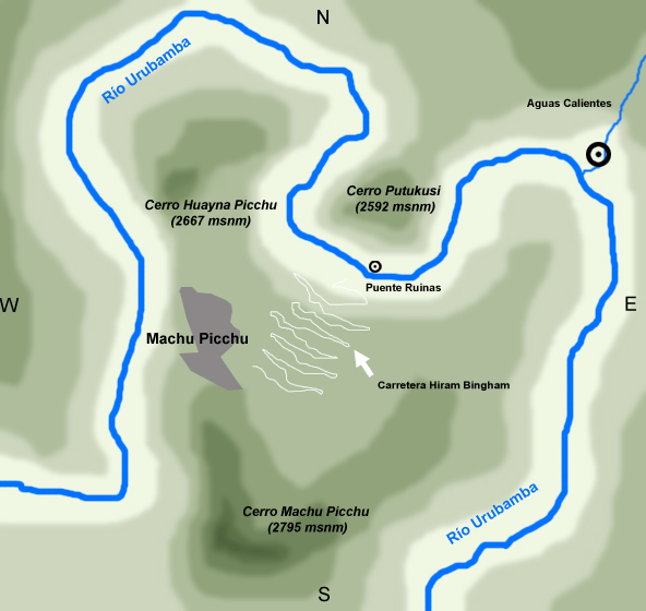
Español: Mapa de ubicación de Machu Picchu con respecto a los cerros Machu y Huayna Picchu y el pueblo de Aguas Calientes.
English: Location Map of Machu Picchu over the hills Machu and Huayna Picchu and Aguas Calientes.
Français : Carte de localisation du site de Machu Picchu par rapport aux montagnes Machu et Huayna Picchu, et le village Aguas Calientes. |
| Taariikhda | |
| Xigasho | Shaqadayda |
| Qoraa | Pablopablo (yo) (myself) |
| Ogolaasho (Dib u isticmaalka faylkaan) |
Mine (mio) |
| Other versions |
Derivative works of this file: |
Laysinka
I, the copyright holder of this work, hereby publish it under the following licenses:

|
Permission is granted to copy, distribute and/or modify this document under the terms of the GNU Free Documentation License, Version 1.2 or any later version published by the Free Software Foundation; with no Invariant Sections, no Front-Cover Texts, and no Back-Cover Texts. A copy of the license is included in the section entitled GNU Free Documentation License. |
| This file is licensed under the Creative Commons Attribution-Share Alike 3.0 Unported license. | ||
| ||
| This licensing tag was added to this file as part of the GFDL licensing update. |
This file is licensed under the Creative Commons Attribution-Share Alike 2.5 Generic, 2.0 Generic and 1.0 Generic license.
- Waad fasaxantahay:
- la wadaagid – koobi gareenta, qaybinta iyo gudbinta shaqada
- to remix – in shaqada la waafajiyo
- Shuruudaha soo socda:
- Astaan – You must give appropriate credit, provide a link to the license, and indicate if changes were made. You may do so in any reasonable manner, but not in any way that suggests the licensor endorses you or your use.
- si isku mid la wadaag – If you remix, transform, or build upon the material, you must distribute your contributions under the same or compatible license as the original.
You may select the license of your choice.
Taariikhda faylka
Riix taariikhda/waqtiga si aad u argto faylka sida oo ahaa markiisa hore.
| Taariikhda/Waqtiga | Sawir yar | Cabirka | Isticmaale | Ka hadalka | |
|---|---|---|---|---|---|
| kan hadda | 17:07, 3 Maaj 2007 | | 592 × 560 (177 KB) | Pablopablo | {{Information |Description=ubicación de Machu Picchu en el Cañón del urubamba |Source=trabajo propio |Date=2007 |Author=pablopablo }} |
| 19:30, 25 Febraayo 2007 |  | 592 × 560 (86 KB) | Pablopablo | Mapa de ubicación de Machu Picchu con respecto a los cerros Machu y Huayna Picchu y el pueblo de Aguas Calientes. |
Faylka lagu isticmaalay
Ma jiraan bogag adeegsanaya faylkaan.
isticmaalka faylka aduunka
Wikisyada kale ee soosocda ayaa adeegsanaya faylka:
- Ku isticmaal ast.wikipedia.org
- Ku isticmaal de.wikipedia.org
- Ku isticmaal en.wikipedia.org
- Ku isticmaal eo.wikipedia.org
- Ku isticmaal fr.wikipedia.org
- Ku isticmaal gl.wikipedia.org
- Ku isticmaal he.wikipedia.org
- Ku isticmaal it.wikipedia.org
- Ku isticmaal it.wikivoyage.org
- Ku isticmaal oc.wikipedia.org
- Ku isticmaal pt.wikipedia.org
- Ku isticmaal qu.wikipedia.org
- Ku isticmaal sv.wikipedia.org
- Ku isticmaal zh.wikipedia.org