
File:Nile watershed topo.png
Cabirka muuqaalkaan: 285 × 599 pixels. Waxyaabaha kale xalinta: 114 × 240 pixels | 554 × 1,164 pixels.
Faylka asalka ah (554 × 1,164 pixels, weyninka faylka : 560 KB, nuuca MIME: image/png)
Qoraal kooban
| Sharaxaad |
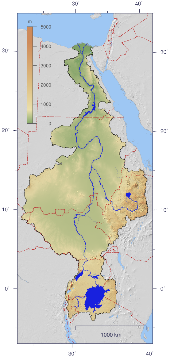
English: Course and Watershed of the Nile with topography shading and political boundaries.
Deutsch: Verlauf und Einzugsgebiet des Nils mit Reliefschattierung und Staatsgrenzen.
العربية: مجرى نهر النيل و الأراضي التي تروى بماءه مع طوبوغرافيا الأرض المحيطة به و الحدود السياسية |
| Taariikhda | |
| Xigasho | The map has been created with the Generic Mapping Tools: http://gmt.soest.hawaii.edu/ using additional public domain data from the VMAP0 and HYDRO1K data sets. The map is in Transverse Mercator projection with central meridian at 32.5° east. |
| Qoraa | Imagico |
| Ogolaasho (Dib u isticmaalka faylkaan) |
This file is licensed under the Creative Commons Attribution-Share Alike 2.5 Generic license.
|
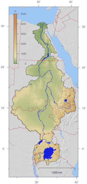
| Other versions | Image:Nile_watershed_plain.png |
Laysinka
I, the copyright holder of this work, hereby publish it under the following license:
This file is licensed under the Creative Commons Attribution-Share Alike 2.5 Generic license.
- Waad fasaxantahay:
- la wadaagid – koobi gareenta, qaybinta iyo gudbinta shaqada
- to remix – in shaqada la waafajiyo
- Shuruudaha soo socda:
- Astaan – You must give appropriate credit, provide a link to the license, and indicate if changes were made. You may do so in any reasonable manner, but not in any way that suggests the licensor endorses you or your use.
- si isku mid la wadaag – If you remix, transform, or build upon the material, you must distribute your contributions under the same or compatible license as the original.
Taariikhda faylka
Riix taariikhda/waqtiga si aad u argto faylka sida oo ahaa markiisa hore.
| Taariikhda/Waqtiga | Sawir yar | Cabirka | Isticmaale | Ka hadalka | |
|---|---|---|---|---|---|
| kan hadda | 21:06, 25 Agoosto 2016 | | 554 × 1,164 (560 KB) | Janitoalevic | Updated borders. |
| 13:59, 4 Jannaayo 2007 |  | 554 × 1,164 (527 KB) | Imagico | {{Information |Description= {{en|Course and Watershed of the Nile with topography shading and political boundaries.}} {{de|Verlauf und Einzugsgebiet des Nils mit Reliefschattierung und Staatsgrenzen.}} |Source=The map has been created with the [[:en:Gener |
Faylka lagu isticmaalay
waxyaabaha soo socda ee 2 boggag ayaa isticmaalaya faylkaan:
isticmaalka faylka aduunka
Wikisyada kale ee soosocda ayaa adeegsanaya faylka:
- Ku isticmaal af.wikipedia.org
- Ku isticmaal ar.wikipedia.org
- Ku isticmaal as.wikipedia.org
- Ku isticmaal ca.wikipedia.org
- Ku isticmaal cdo.wikipedia.org
- Ku isticmaal ckb.wikipedia.org
- Ku isticmaal crh.wikipedia.org
- Ku isticmaal da.wikipedia.org
- Ku isticmaal en.wikipedia.org
- Ku isticmaal es.wikipedia.org
- Ku isticmaal fa.wikipedia.org
- Ku isticmaal fr.wikipedia.org
- Ku isticmaal fy.wikipedia.org
- Ku isticmaal hy.wikipedia.org
- Ku isticmaal hyw.wikipedia.org
- Ku isticmaal incubator.wikimedia.org
- Ku isticmaal ja.wikipedia.org
- Ku isticmaal ja.wikibooks.org
- Ku isticmaal jbo.wikipedia.org
- Ku isticmaal kbd.wikipedia.org
- Ku isticmaal lez.wikipedia.org
- Ku isticmaal lv.wikipedia.org
- Ku isticmaal new.wikipedia.org
- Ku isticmaal nl.wikipedia.org
- Ku isticmaal nn.wikipedia.org
- Ku isticmaal no.wikipedia.org
- Ku isticmaal nso.wikipedia.org
- Ku isticmaal pms.wikipedia.org
- Ku isticmaal roa-rup.wikipedia.org
- Ku isticmaal ru.wikipedia.org
- Ku isticmaal sco.wikipedia.org
- Ku isticmaal si.wikipedia.org
- Ku isticmaal sl.wikipedia.org
View more global usage of this file.