
File:Rhodes NLT Landsat7.png
Cabirka muuqaalkaan: 605 × 600 pixels. Waxyaabaha kale xalinta: 242 × 240 pixels | 484 × 480 pixels | 775 × 768 pixels | 1,033 × 1,024 pixels | 1,948 × 1,931 pixels.
Faylka asalka ah (1,948 × 1,931 pixels, weyninka faylka : 5.65 MB, nuuca MIME: image/png)
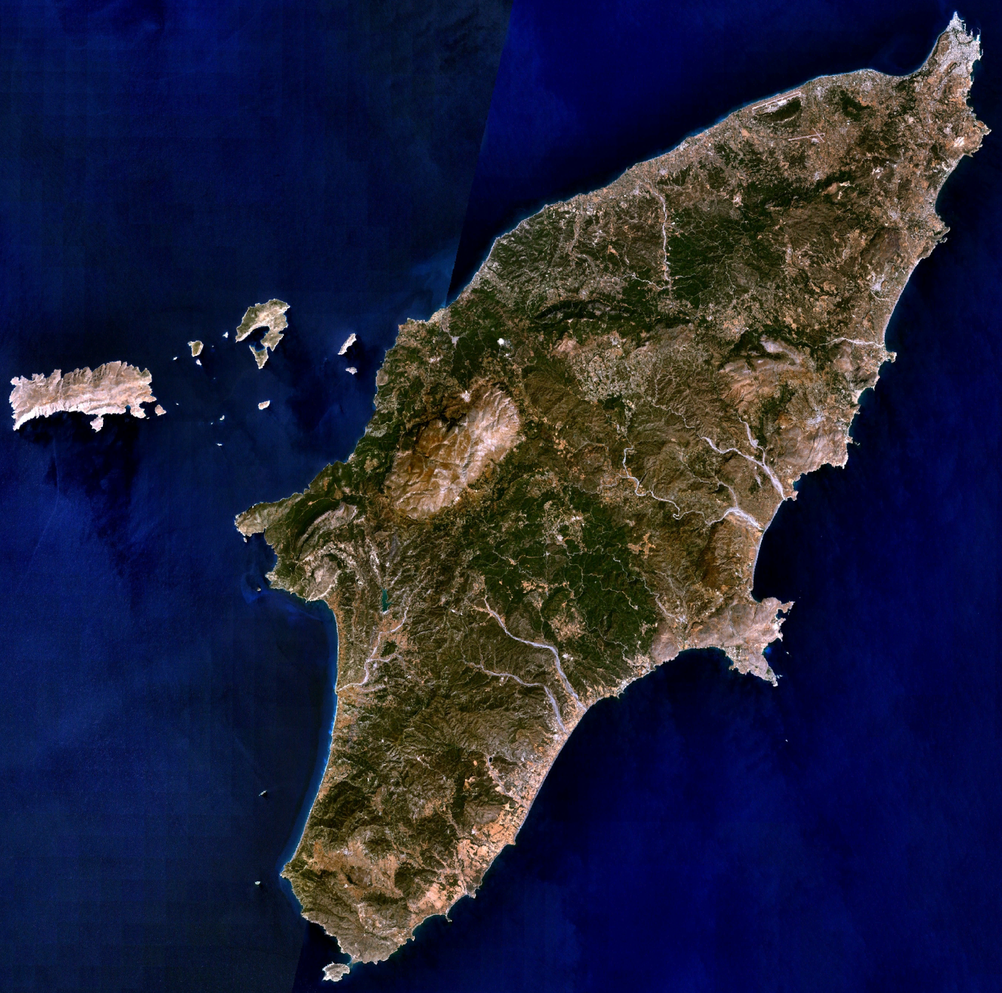
| Sharaxaad | Visible colour satellite image of Rhodes. | |||
| Xigasho |
Screenshot from NASA World Wind, NLT Landsat7 layer. Coordinates: worldwind://goto/world=Earth&lat=36.16654&lon=27.93315&alt=80698 |
|||
| Qoraa | Sawir: NASA | |||
| Ogolaasho (Dib u isticmaalka faylkaan) |
|
|||
| Other versions | Image:Rodas.png |

Taariikhda faylka
Riix taariikhda/waqtiga si aad u argto faylka sida oo ahaa markiisa hore.
| Taariikhda/Waqtiga | Sawir yar | Cabirka | Isticmaale | Ka hadalka | |
|---|---|---|---|---|---|
| kan hadda | 20:29, 16 Abriil 2006 | | 1,948 × 1,931 (5.65 MB) | Hautala | {{Information| |Description=Visible colour satellite image of Rhodes. |Source=Screenshot from NASA World Wind, NLT Landsat7 layer. |Date= |Author= |Permission={{PD-WorldWind}} |other_versions= }} |
Faylka lagu isticmaalay
waxyaabaha soo socda ee bog ayaa adeegsanaya faylkaan:
isticmaalka faylka aduunka
Wikisyada kale ee soosocda ayaa adeegsanaya faylka:
- Ku isticmaal ab.wikipedia.org
- Ku isticmaal als.wikipedia.org
- Ku isticmaal an.wikipedia.org
- Ku isticmaal ar.wikipedia.org
- Ku isticmaal az.wikipedia.org
- Ku isticmaal be-tarask.wikipedia.org
- Ku isticmaal be.wikipedia.org
- Ku isticmaal bg.wikipedia.org
- Ku isticmaal ca.wikipedia.org
- Ku isticmaal ceb.wikipedia.org
- Ku isticmaal cs.wikipedia.org
- Ku isticmaal da.wikipedia.org
- Ku isticmaal de.wikipedia.org
- Ku isticmaal el.wikipedia.org
- Ku isticmaal en.wikipedia.org
- Ku isticmaal eu.wikipedia.org
- Ku isticmaal fi.wikipedia.org
- Ku isticmaal fr.wikipedia.org
View more global usage of this file.