
File:Saharan topographic elements map.png
Cabirka muuqaalkaan: 800 × 395 pixels. Waxyaabaha kale xalinta: 320 × 158 pixels | 640 × 316 pixels | 1,396 × 690 pixels.
Faylka asalka ah (1,396 × 690 pixels, weyninka faylka : 757 KB, nuuca MIME: image/png)
Qoraal kooban
| Sharaxaad |
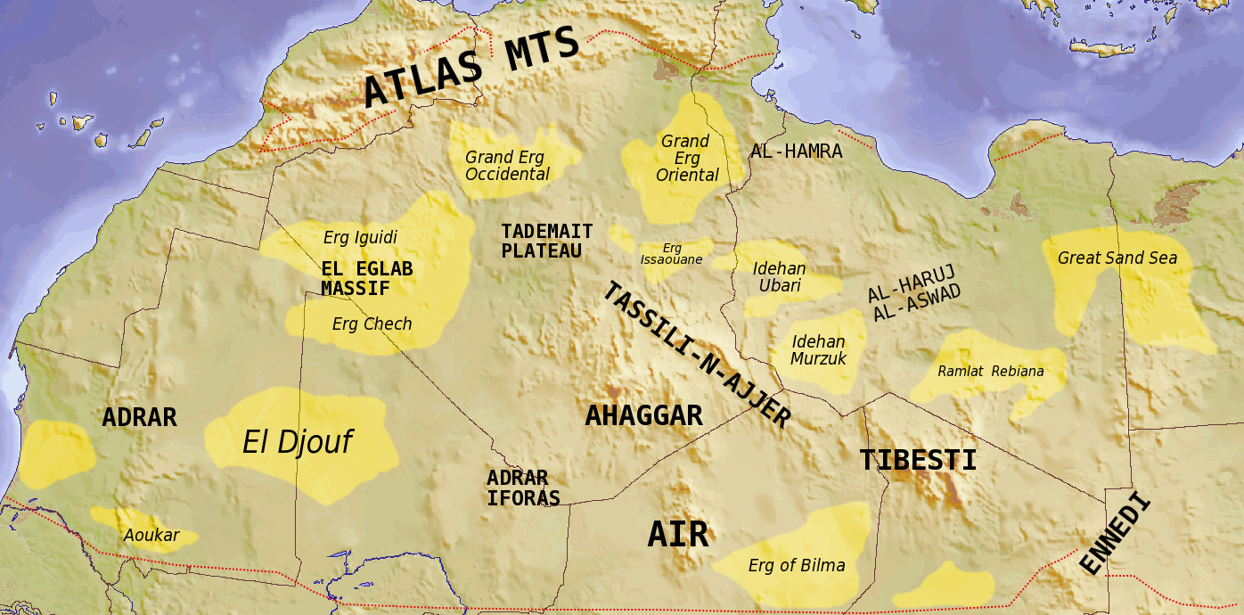
English: Map showing major Dune seas (ergs) and Mountain ranges of the Sahara. Red dashed line shows approximate limit of the Sahara. National borders in grey. Dune seas in yellow.
Derived from Blank map Image:Africa_topography_map_with_borders.png. Data taken from http://www.sahara-overland.com image of Michlein Map and Geology.com's Sahara Desert Map.
العربية: السمات الطبوغرافية الرئيسية للمنطقة الصحراوية |
|
| Taariikhda | ||
| Xigasho | Own work by uploader Derived from Blank map Image:Africa_topography_map_with_borders.png | |
| Qoraa | T L Miles | |
| Other versions |
File:Africa_topography_map_with_borders.png
|

Laysinka
I, the copyright holder of this work, hereby publish it under the following licenses:
This file is licensed under the Creative Commons Attribution-Share Alike 3.0 Unported license.
- Waad fasaxantahay:
- la wadaagid – koobi gareenta, qaybinta iyo gudbinta shaqada
- to remix – in shaqada la waafajiyo
- Shuruudaha soo socda:
- Astaan – You must give appropriate credit, provide a link to the license, and indicate if changes were made. You may do so in any reasonable manner, but not in any way that suggests the licensor endorses you or your use.
- si isku mid la wadaag – If you remix, transform, or build upon the material, you must distribute your contributions under the same or compatible license as the original.

|
Permission is granted to copy, distribute and/or modify this document under the terms of the GNU Free Documentation License, Version 1.2 or any later version published by the Free Software Foundation; with no Invariant Sections, no Front-Cover Texts, and no Back-Cover Texts. A copy of the license is included in the section entitled GNU Free Documentation License. |
You may select the license of your choice.
| Annotations | This image is annotated: View the annotations at Commons |
Taariikhda faylka
Riix taariikhda/waqtiga si aad u argto faylka sida oo ahaa markiisa hore.
| Taariikhda/Waqtiga | Sawir yar | Cabirka | Isticmaale | Ka hadalka | |
|---|---|---|---|---|---|
| kan hadda | 18:39, 24 Luuliyo ama Luulyo 2008 | | 1,396 × 690 (757 KB) | T L Miles | {{Information |Description={{en|1=Map showing major Dune seas (ergs) and Mountain ranges of the Sahara. Red dashed line shows approximate limit of the Sahara. National borders in grey. Dune seas in yellow. Derived from Blank map [[:Image:Africa_topogra |
Faylka lagu isticmaalay
waxyaabaha soo socda ee bog ayaa adeegsanaya faylkaan:
isticmaalka faylka aduunka
Wikisyada kale ee soosocda ayaa adeegsanaya faylka:
- Ku isticmaal af.wikipedia.org
- Ku isticmaal ar.wikipedia.org
- Ku isticmaal arz.wikipedia.org
- Ku isticmaal az.wikipedia.org
- Ku isticmaal ba.wikipedia.org
- Ku isticmaal be.wikipedia.org
- Ku isticmaal bg.wikipedia.org
- Ku isticmaal cs.wikipedia.org
- Ku isticmaal da.wikipedia.org
- Ku isticmaal de.wikipedia.org
- Ku isticmaal en.wikipedia.org
- Ku isticmaal eo.wikipedia.org
- Ku isticmaal es.wikipedia.org
- Ku isticmaal eu.wikipedia.org
- Ku isticmaal fa.wikipedia.org
- Ku isticmaal fi.wikipedia.org
- Ku isticmaal frr.wikipedia.org
- Ku isticmaal fr.wikipedia.org
View more global usage of this file.