
File:Somalia ethnic grps 2002.jpg

Cabirka muuqaalkaan: 800 × 551 pixels. Waxyaabaha kale xalinta: 320 × 220 pixels | 640 × 441 pixels | 1,024 × 705 pixels | 1,418 × 976 pixels.
Faylka asalka ah (1,418 × 976 pixels, weyninka faylka : 140 KB, nuuca MIME: image/jpeg)
magaceygu wa zakaria ismail sheikh meesha darood waa 35%

|
This ethnographic map image could be re-created using vector graphics as an SVG file. This has several advantages; see Commons:Media for cleanup for more information. If an SVG form of this image is available, please upload it and afterwards replace this template with
{{vector version available|new image name}}.
It is recommended to name the SVG file “Somalia ethnic grps 2002.svg”—then the template Vector version available (or Vva) does not need the new image name parameter. |


Qoraal kooban
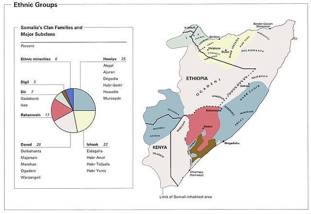
Distribution of Somali ethnic groups.
Source: "Ethnic Groups from Somalia Summary Map, CIA 2002" (https://www.lib.utexas.edu/maps/africa/somalia_ethnic_grps_2002.jpg)
Perry-Castaneda Library Map Collection, University of Texas at Austin
According to the source's table of contents, this is a CIA map, thus placing the image in the public domain.
Laysinka
This work is in the public domain in the United States because it is a work prepared by an officer or employee of the United States Government as part of that person’s official duties under the terms of Title 17, Chapter 1, Section 105 of the US Code.
Note: This only applies to original works of the Federal Government and not to the work of any individual U.S. state, territory, commonwealth, county, municipality, or any other subdivision. This template also does not apply to postage stamp designs published by the United States Postal Service since 1978. (See § 313.6(C)(1) of Compendium of U.S. Copyright Office Practices). It also does not apply to certain US coins; see The US Mint Terms of Use.
|
 | |
| This file has been identified as being free of known restrictions under copyright law, including all related and neighboring rights. | ||
Taariikhda faylka
Riix taariikhda/waqtiga si aad u argto faylka sida oo ahaa markiisa hore.
| Taariikhda/Waqtiga | Sawir yar | Cabirka | Isticmaale | Ka hadalka | |
|---|---|---|---|---|---|
| kan hadda | 13:22, 22 Mey 2021 | | 1,418 × 976 (140 KB) | Gyrofrog | Reverted to version as of 16:28, 17 June 2006 (UTC). This is a different map altogether, with different attribution and unstated permission for re-use. THe existing verbiage on the page fers to the earlier version(s) of the CIA map. |
| 13:37, 18 Mey 2021 | No thumbnail | 831 × 1,024 (149 KB) | Turwaaq | ||
| 16:28, 17 Juun 2006 |  | 1,418 × 976 (140 KB) | GhePeU | ||
| 04:18, 8 Diseembar 2005 |  | 1,418 × 976 (103 KB) | Gyrofrog | Source: Perry-Castaneda Library Map Collection, University of Texas at Austin<br /> URL: http://www.lib.utexas.edu/maps/africa/somalia_ethnic_grps_2002.jpg<br /> According to the source's [http://www.lib.utexas.edu/maps/somalia.html table of contents], th |
Faylka lagu isticmaalay
Ma jiraan bogag adeegsanaya faylkaan.
isticmaalka faylka aduunka
Wikisyada kale ee soosocda ayaa adeegsanaya faylka:
- Ku isticmaal af.wikipedia.org
- Ku isticmaal ar.wikipedia.org
- Ku isticmaal ca.wikipedia.org
- Ku isticmaal de.wikipedia.org
- Ku isticmaal en.wikipedia.org
- Ku isticmaal en.wikibooks.org
- Ku isticmaal es.wikipedia.org
- Ku isticmaal fi.wikipedia.org
- Ku isticmaal fr.wikipedia.org
- Ku isticmaal ha.wikipedia.org
- Ku isticmaal nl.wikipedia.org
- Ku isticmaal no.wikipedia.org
- Ku isticmaal sv.wikipedia.org
- Ku isticmaal zh.wikipedia.org