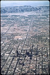
File:The View of Phoenix's Urban Sprawl from 4000 Ft. South Mountain in Background , 6 1972.jpg

Faylka asalka ah (2,013 × 3,000 pixels, weyninka faylka : 1.15 MB, nuuca MIME: image/jpeg)
Faylkaan wuxuu ka socdaa Wikimedia Commons waxaana adeegsan kara mashaariic kale. Sharaxaadda ku taal boggeeda faylka ee bogga sharaxaadda faylka halkan hoose ayaa lagu muujiyey.
| This is a retouched picture, which means that it has been digitally altered from its original version. The original can be viewed here: THE VIEW OF PHOENIX'S URBAN SPRAWL FROM 4000 FT. SOUTH MOUNTAIN IN BACKGROUND - NARA - 544073.jpg:
|
Qoraal kooban
| Cornelius M. Keyes: The View of Phoenix's Urban Sprawl from 4000 Ft. South Mountain in Background , 6/1972
|
|||||||||||||||||||||||||||
|---|---|---|---|---|---|---|---|---|---|---|---|---|---|---|---|---|---|---|---|---|---|---|---|---|---|---|---|
| Artist |
|
||||||||||||||||||||||||||
| Qoraa |
Keyes, Cornelius M. (Cornelius Michael), 1944-, Photographer (NARA record: 8463989) |
||||||||||||||||||||||||||
| Record creator InfoField | Environmental Protection Agency. (12/02/1970 - ) | ||||||||||||||||||||||||||
| Title |
View of Phoenix's Urban Sprawl from 4000 Ft. South Mountain in Background , 6/1972 |
||||||||||||||||||||||||||
| Object type |
sawir |
||||||||||||||||||||||||||
| Genre |
documentary photography |
||||||||||||||||||||||||||
| Sharaxaad |
English: :::*Aerial view of Phoenix, Arizona, in June 1972.
|
||||||||||||||||||||||||||
| Depicted place |
Phoenix (Maricopa County, Arizona, United States, North and Central America) inhabited place (33°25′59″N 112°04′12″W / 33.433°N 112.07°W / 33.433; -112.07; NARA geographical record) |
||||||||||||||||||||||||||
| Taariikhda |
Juun 1972 date QS:P571,+1972-06-00T00:00:00Z/10 |
||||||||||||||||||||||||||
| Publication date |
circa |
||||||||||||||||||||||||||
| Medium |
photographic emulsion |
||||||||||||||||||||||||||
| Collection |
institution QS:P195,Q38945047
Still Picture Records Section, Special Media Archives Services Division (NWCS-S) |
||||||||||||||||||||||||||
| Accession number |
|
||||||||||||||||||||||||||
| Object location |
|
||||||||||||||||||||||||||
| Place of creation |
Gobolada Isku Tegay ee Ameerika |
||||||||||||||||||||||||||
| Record ID InfoField |
NAIL Control Number: NWDNS-412-DA-1580
|
||||||||||||||||||||||||||
| References | |||||||||||||||||||||||||||
| Xigasho | U.S. National Archives and Records Administration | ||||||||||||||||||||||||||
| Other versions |
Please do not overwrite this file: any cropping or other restoration work should be uploaded with a new name and linked in this page's "other versions=" parameter, so that this file represents the exact file found in the NARA catalog record to which it links. The metadata on this page was imported directly from NARA's catalog record; additional descriptive text may be added by Wikimedians to the template below with the "description=" parameter, but please do not modify the other fields. translate
|
||||||||||||||||||||||||||
| Object location | 33° 25′ 58.8″ N, 112° 04′ 12″ W | View this and other nearby images on: OpenStreetMap |
|---|
Laysinka
| Public domainPublic domainfalsefalse |
This image (or other media) is a work of an Environmental Protection Agency employee, taken or made as part of that person's official duties. As works of the U.S. federal government, all EPA images are in the public domain.
|
||
| العربية ∙ Deutsch ∙ English ∙ eesti ∙ italiano ∙ 日本語 ∙ македонски ∙ Nederlands ∙ polski ∙ português ∙ sicilianu ∙ slovenščina ∙ ไทย ∙ українська ∙ 简体中文 ∙ 繁體中文 ∙ +/− |
Captions
Items portrayed in this file
depicts Ingiriisi
fabrication method Ingiriisi
aerial photography Ingiriisi
coordinates of depicted place Ingiriisi
33°25'59"N, 112°4'12"W
MIME type Ingiriisi
image/jpeg
Taariikhda faylka
Riix taariikhda/waqtiga si aad u argto faylka sida oo ahaa markiisa hore.
| Taariikhda/Waqtiga | Sawir yar | Cabirka | Isticmaale | Ka hadalka | |
|---|---|---|---|---|---|
| kan hadda | 13:51, 29 Mey 2022 |  | 2,013 × 3,000 (1.15 MB) | Hohum | Reworked from original. |
| 22:21, 24 Agoosto 2018 |  | 2,099 × 3,150 (1.56 MB) | Dcflyer | User created page with UploadWizard |
Faylka lagu isticmaalay
waxyaabaha soo socda ee bog ayaa adeegsanaya faylkaan:
isticmaalka faylka aduunka
Wikisyada kale ee soosocda ayaa adeegsanaya faylka:
- Ku isticmaal en.wikipedia.org
- Ku isticmaal ro.wikipedia.org
- Ku isticmaal www.wikidata.org
Metadata
Faylkani wuxuu ka kooban yahay macluumaad dheeri ah, oo laga yaabo inuu ku daray kamaradda dijitaalka ama scanner oo loo isticmaalay in lagu abuuro ama lagu dijitilaasgareeyo.
Haddii faylka wax laga beddelay xaaladdiisii hore, faahfaahinta qaar lagama yaabo inay si buuxda u muujiyaan faylka wax laga beddelay.
| Image title | Portrait |
|---|---|
| User comments | Portrait |
| JPEG file comment | Portrait |
| Orientation | Normal |
| Horizontal resolution | 300 dpi |
| Vertical resolution | 300 dpi |
| Software used | GIMP 2.10.30 |
| File change date and time | 14:50, 29 Mey 2022 |
| Color space | sRGB |
| Unique ID of original document | xmp.did:fec66a65-ad44-47bd-aa2d-398091fe79c1 |


