
File:Togo-karte-politisch.png

Cabirka muuqaalkaan: 408 × 599 pixels. Waxyaabaha kale xalinta: 163 × 240 pixels | 425 × 624 pixels.
Faylka asalka ah (425 × 624 pixels, weyninka faylka : 136 KB, nuuca MIME: image/png)
Qoraal kooban
| Sharaxaad |
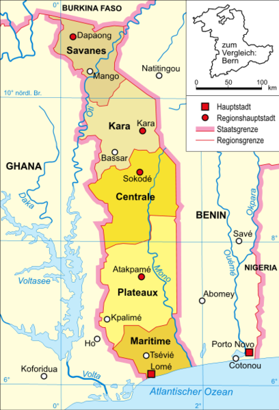
Deutsch: Politische Karte Togos |
| Taariikhda |
13. Januar 2006 |
| Xigasho | Selbst erstellt, own work by Domenico-de-ga, |
| Qoraa | Domenico-de-ga |
Laysinka
Domenico-de-ga from de.wikipedia.org, the copyright holder of this work, hereby publishes it under the following license:

|
Permission is granted to copy, distribute and/or modify this document under the terms of the GNU Free Documentation License, Version 1.2 or any later version published by the Free Software Foundation; with no Invariant Sections, no Front-Cover Texts, and no Back-Cover Texts. A copy of the license is included in the section entitled GNU Free Documentation License. |
| This file is licensed under the Creative Commons Attribution-Share Alike 3.0 Unported license. | ||
| Attribution: Domenico-de-ga | ||
| ||
| This licensing tag was added to this file as part of the GFDL licensing update. |
Original upload log
Transferred from de.wikipedia to Commons by Martin H. using CommonsHelper.
The original description page was here. All following user names refer to de.wikipedia.
- 2006-01-13 15:20 Domenico-de-ga 425×624×??? (139500 bytes) * Bildbeschreibung: politische Karte Togos * Quelle: selbst erstellt * Zeichner: [[Benutzer:Domenico-de-ga|Domenico-de-ga]] * Datum: 13. Januar 2006 {{Bild-GFDL}}
Taariikhda faylka
Riix taariikhda/waqtiga si aad u argto faylka sida oo ahaa markiisa hore.
| Taariikhda/Waqtiga | Sawir yar | Cabirka | Isticmaale | Ka hadalka | |
|---|---|---|---|---|---|
| kan hadda | 00:50, 18 Sebteembar 2008 | | 425 × 624 (136 KB) | File Upload Bot (Magnus Manske) | {{BotMoveToCommons|de.wikipedia}} {{Information |Description={{de|Politische Karte Togos}} |Source=Transferred from [http://de.wikipedia.org de.wikipedia]; transferred to Commons by User:Martin H. using [http://tools.wikimedia.de/~magnus/commonshelpe |
Faylka lagu isticmaalay
waxyaabaha soo socda ee bog ayaa adeegsanaya faylkaan:
isticmaalka faylka aduunka
Wikisyada kale ee soosocda ayaa adeegsanaya faylka:
- Ku isticmaal be-tarask.wikipedia.org
- Ku isticmaal be.wikipedia.org
- Ku isticmaal br.wikipedia.org
- Ku isticmaal ca.wikipedia.org
- Ku isticmaal ceb.wikipedia.org
- Ku isticmaal cs.wikipedia.org
- Ku isticmaal da.wikipedia.org
- Ku isticmaal de.wikipedia.org
- Ku isticmaal es.wikipedia.org
- Ku isticmaal eu.wikipedia.org
- Ku isticmaal frr.wikipedia.org
- Ku isticmaal ha.wikipedia.org
- Ku isticmaal hu.wikipedia.org
- Ku isticmaal lt.wikipedia.org
- Ku isticmaal mdf.wikipedia.org
- Ku isticmaal nds.wikipedia.org
- Ku isticmaal nl.wikipedia.org
- Ku isticmaal pl.wikipedia.org
- Ku isticmaal pt.wikipedia.org
- Ku isticmaal ro.wikipedia.org
- Ku isticmaal ru.wikipedia.org
- Ku isticmaal sv.wikipedia.org
- Ku isticmaal tr.wikipedia.org
- Ku isticmaal tr.wiktionary.org
- Ku isticmaal uk.wikipedia.org
- Ku isticmaal www.wikidata.org