
File:Wayne County Michigan Incorporated and Unincorporated areas Detroit highlighted.svg

Size of this PNG preview of this SVG file: 800 × 533 pixels. Waxyaabaha kale xalinta: 320 × 213 pixels | 640 × 427 pixels | 1,024 × 683 pixels | 1,280 × 853 pixels | 2,560 × 1,707 pixels | 1,200 × 800 pixels.
Faylka asalka ah (SVG file, nominally 1,200 × 800 pixels, file size: 136 KB)
| Sharaxaad |
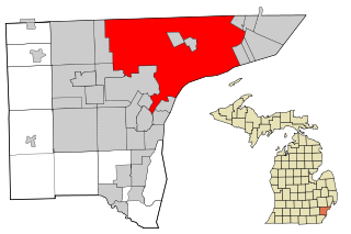
This map shows the incorporated and unincorporated areas in Wayne County, Michigan.
|
||||||||
| Taariikhda | |||||||||
| Xigasho | My own work, based on public domain information. Based on similar map concepts by Ixnayonthetimmay | ||||||||
| Qoraa | Arkyan | ||||||||
| Ogolaasho (Dib u isticmaalka faylkaan) |
I, the copyright holder of this work, hereby publish it under the following licenses:
This file is licensed under the Creative Commons Attribution-Share Alike 2.5 Generic, 2.0 Generic and 1.0 Generic license.
You may select the license of your choice. |

Taariikhda faylka
Riix taariikhda/waqtiga si aad u argto faylka sida oo ahaa markiisa hore.
| Taariikhda/Waqtiga | Sawir yar | Cabirka | Isticmaale | Ka hadalka | |
|---|---|---|---|---|---|
| kan hadda | 19:30, 23 Abriil 2007 | | 1,200 × 800 (136 KB) | Shereth | {{Information |Description=This map shows the incorporated and unincorporated areas in Wayne County, Michigan, highlighting Detroit in red. I created it in Inksc |
Faylka lagu isticmaalay
Ma jiraan bogag adeegsanaya faylkaan.
isticmaalka faylka aduunka
Wikisyada kale ee soosocda ayaa adeegsanaya faylka:
- Ku isticmaal af.wikipedia.org
- Ku isticmaal ang.wikipedia.org
- Ku isticmaal anp.wikipedia.org
- Ku isticmaal ar.wikipedia.org
- Ku isticmaal arz.wikipedia.org
- Ku isticmaal ast.wikipedia.org
- Ku isticmaal as.wikipedia.org
- Ku isticmaal av.wikipedia.org
- Ku isticmaal awa.wikipedia.org
- Ku isticmaal azb.wikipedia.org
- Ku isticmaal az.wikipedia.org
- Ku isticmaal bh.wikipedia.org
- Ku isticmaal bjn.wikipedia.org
- Ku isticmaal bn.wikipedia.org
- Ku isticmaal bs.wikipedia.org
- Ku isticmaal ca.wikipedia.org
- Ku isticmaal cbk-zam.wikipedia.org
- Ku isticmaal ceb.wikipedia.org
- Ku isticmaal ckb.wikipedia.org
- Ku isticmaal dty.wikipedia.org
- Ku isticmaal dv.wikipedia.org
- Ku isticmaal el.wikipedia.org
- Ku isticmaal en.wikipedia.org
View more global usage of this file.