
File:Ain al-Assad air base, 8 jan 2020.png

Cabirka muuqaalkaan: 800 × 453 pixels. Waxyaabaha kale xalinta: 320 × 181 pixels | 640 × 362 pixels | 1,024 × 580 pixels | 1,280 × 724 pixels | 2,000 × 1,132 pixels.
Faylka asalka ah (2,000 × 1,132 pixels, weyninka faylka : 4.5 MB, nuuca MIME: image/png)
Qoraal kooban
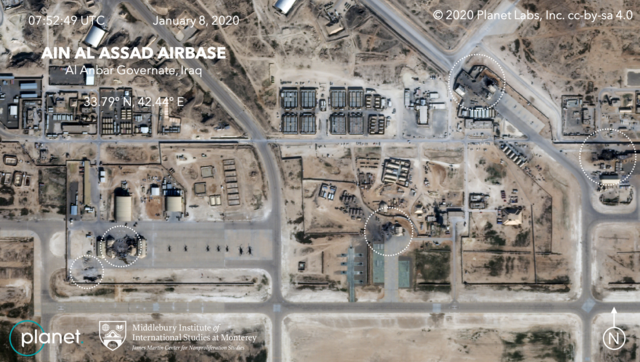
| Sharaxaad | Satellite image, showing the damage to at least five structures at Ain al-Assad air base in Iraq in a series of precision missile strikes launched by Iran |
| Taariikhda | |
| Xigasho |
First upload: Brumfiel, Geoff; Welna, David (8 January 2020). Satellite Photos Reveal Extent Of Damage From Iranian Strike On Air Base In Iraq. NPR. Current upload: Garger, Kenneth (8 January 2020). Before-and-after satellite images show damage to Iraqi base hit by Iran. New York Post. |
| Qoraa | Planet Labs, Inc. / Middlebury Institute of International Studies at Monterey |
| Ogolaasho (Dib u isticmaalka faylkaan) |
There is a copyright notice in the upper right of this image. "© 2020 Planet Labs, Inc. cc-by-sa 4.0" |
Laysinka
This file is licensed under the Creative Commons Attribution-Share Alike 4.0 International license.
Attribution: Planet Labs, Inc.
- Waad fasaxantahay:
- la wadaagid – koobi gareenta, qaybinta iyo gudbinta shaqada
- to remix – in shaqada la waafajiyo
- Shuruudaha soo socda:
- Astaan – You must give appropriate credit, provide a link to the license, and indicate if changes were made. You may do so in any reasonable manner, but not in any way that suggests the licensor endorses you or your use.
- si isku mid la wadaag – If you remix, transform, or build upon the material, you must distribute your contributions under the same or compatible license as the original.
Taariikhda faylka
Riix taariikhda/waqtiga si aad u argto faylka sida oo ahaa markiisa hore.
| Taariikhda/Waqtiga | Sawir yar | Cabirka | Isticmaale | Ka hadalka | |
|---|---|---|---|---|---|
| kan hadda | 06:14, 9 Jannaayo 2020 | | 2,000 × 1,132 (4.5 MB) | EnchanterTim | Higher resolution from: https://nypost.com/2020/01/08/before-and-after-satellite-images-show-damage-to-iraqi-base-hit-by-iran/ |
| 19:52, 8 Jannaayo 2020 |  | 800 × 449 (805 KB) | Cold Season | {{Information |Description= Satellite image, showing the damage to at least five hangars and buildings at Ain al-Assad air base in Iraq in a series of precision missile strikes launched by Iran |Source= [https://www.npr.org/2020/01/08/794517031/satellite-photos-reveal-extent-of-damage-at-al-assad-air-base?t=1578512699906 Satellite Photos Reveal Extent Of Damage From Iranian Strike On Air Base In Iraq]. NPR. |Date= 8 January 2020 |Author= Planet Labs Inc./Middlebury Institute |Permission= |ot... |
Faylka lagu isticmaalay
waxyaabaha soo socda ee bog ayaa adeegsanaya faylkaan:
isticmaalka faylka aduunka
Wikisyada kale ee soosocda ayaa adeegsanaya faylka:
- Ku isticmaal ar.wikipedia.org
- Ku isticmaal be.wikipedia.org
- Ku isticmaal ca.wikipedia.org
- Ku isticmaal ckb.wikipedia.org
- Ku isticmaal en.wikipedia.org
- Ku isticmaal es.wikipedia.org
- Ku isticmaal fa.wikipedia.org
- Ku isticmaal fi.wikipedia.org
- Ku isticmaal fr.wikipedia.org
- Ku isticmaal he.wikipedia.org
- Ku isticmaal id.wikipedia.org
- Ku isticmaal ja.wikipedia.org
- Ku isticmaal ka.wikipedia.org
- Ku isticmaal ko.wikipedia.org
- Ku isticmaal nl.wikipedia.org
- Ku isticmaal nl.wikinews.org
- Ku isticmaal pnb.wikipedia.org
- Ku isticmaal pt.wikipedia.org
- Ku isticmaal ru.wikipedia.org
- Ku isticmaal ru.wikinews.org
- Ku isticmaal uk.wikipedia.org
- Ku isticmaal ur.wikipedia.org
- Ku isticmaal vi.wikipedia.org
- Ku isticmaal www.wikidata.org
- Ku isticmaal zh.wikipedia.org