
File:Arab league orthographic NED 50m.svg

Size of this PNG preview of this SVG file: 550 × 550 pixels. Waxyaabaha kale xalinta: 240 × 240 pixels | 480 × 480 pixels | 768 × 768 pixels | 1,024 × 1,024 pixels | 2,048 × 2,048 pixels.
Faylka asalka ah (SVG file, nominally 550 × 550 pixels, file size: 350 KB)
Qoraal kooban
| Sharaxaad |
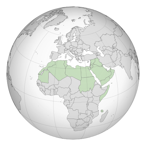
English: A map of the hemisphere showing the Arab League, centred on Libya. using an orthographic projection |
| Taariikhda |
Nofeembar 2009 4 Maaj 2012 (last version uploaded) |
| Xigasho | Created using Grey-green orthographic projections maps and Gringer's Perl script with Natural Earth Data (1:50m resolution, simplified to 0.25px). |
| Qoraa | User:Lexicon (with modifications by others) and Reisio at en.wikipedia / Later version(s) were uploaded by Gringer at en.wikipedia. |
| SVG genesis |
Laysinka
| This work has been released into the public domain by its author, Reisio at Ingiriisi Wikipedia. This applies worldwide. In some countries this may not be legally possible; if so: Reisio grants anyone the right to use this work for any purpose, without any conditions, unless such conditions are required by law. |
| This work has been released into the public domain by its author, Gringer at Ingiriisi Wikipedia. This applies worldwide. In some countries this may not be legally possible; if so: Gringer grants anyone the right to use this work for any purpose, without any conditions, unless such conditions are required by law. |
Original upload log
The original description page was here. All following user names refer to en.wikipedia.
- 2011-02-17 23:20 Gringer 550×550 (357596 bytes) using Natural earth data, easier to customise, recentred to Libya
- 2010-09-25 05:38 Reisio 550×550 (437253 bytes) {{Information |Description={{en|Arab_League_(orthographic_projection)}} |Source=[[Grey-green orthographic projections maps]] |Date=2009-11 |Author=[[:en:User:Lexicon|]] (with modifications by others) |Permission={{PD-self}} |other_versions= }}
.svg)
.svg)
.svg)
.svg)
.svg)
.svg)
.svg)
.svg)
.svg)
.svg)
.svg)
.svg)
.svg)
.svg)
.svg)
.svg)
.svg)
.svg)
.svg)
.svg)
.svg)
.svg)
.svg)
.svg)
.svg)
.svg)
.svg)
.svg)
.svg)
.svg)
.svg)
.svg)
.svg)
.svg)
.svg)
.svg)
.svg)
.svg)
.svg)
.svg)
.svg)
.svg)
.svg)
.svg)
.svg)
.svg)
.svg)
.svg)
.svg)
.svg)
.svg)
.svg)
.svg)
.svg)
.svg)
.svg)
.svg)
.svg)
.svg)
.svg)
.svg)
.svg)
.svg)
.svg)
.svg)
.svg)
.svg)
.svg)
.svg)
.svg)
.svg)
.svg)
.svg)
.svg)

.svg)

.svg)

.svg)
.svg)
.svg)
.svg)
.svg)
.svg)
.svg)


.svg)
.svg)
.svg)
.svg)
.svg)
.svg)
.svg)

.svg)
.svg)
.svg)
.svg)
.svg)
.svg)
.svg)
.svg)
.svg)
.svg)

.svg)
.svg)
.svg)
.svg)
.svg)
.svg)
.svg)
_without_national_boundaries.svg)
.svg)
.svg)
.svg)
.svg)
.svg)
.svg)

.svg)
.svg)
.png)
.svg)
.svg)
.svg)
.svg)

.svg)
.svg)
.svg)
.svg)
.svg)
.svg)
.svg)
.svg)
.svg)
.svg)
.svg)

.svg)
.svg)
.svg)
.svg)
.svg)
.svg)
.svg)
.svg)
.svg)

.svg)
.svg)

.svg)
.svg)
.svg)
.svg)
.svg)
.svg)
.svg)
.svg)
.svg)
.svg)
.svg)
.svg)
.svg)
.svg)
.svg)
.svg)
.svg)
.svg)
.svg)
.svg)
.svg)
.svg)
.svg)
.svg)
.svg)
.svg)
.svg)
_-_Crimea_disputed.svg)
.svg)
.svg)
.svg)
.svg)
.svg)
.svg)
.svg)
.svg)
.svg)
.svg)
.svg)
_political.svg)
.svg)
.svg)
.svg)
.svg)
_-_Crimea_disputed_-_no_borders.svg)
.svg)
.svg)
.svg)
.svg)
.svg)
.svg)
.svg)
.svg)
.svg)
.svg)
.svg)

.svg)
.svg)
.svg)

.png)
.svg)
.svg)
.svg)
.svg)
.svg)
.svg)
.svg)
.svg)
.svg)
.svg)
.svg)
.svg)
.svg)
.svg)
.svg)
.svg)
.svg)
.svg)
.svg)
.svg)
.svg)
.svg)
.svg)
.svg)
.svg)
.svg)
.svg)
.svg)
.svg)
.svg)
.svg)
.svg)
.svg)
.svg)
.png)
.svg)
.svg)
.svg)
_(orthographic_projection).png)
Taariikhda faylka
Riix taariikhda/waqtiga si aad u argto faylka sida oo ahaa markiisa hore.
| Taariikhda/Waqtiga | Sawir yar | Cabirka | Isticmaale | Ka hadalka | |
|---|---|---|---|---|---|
| kan hadda | 19:52, 4 Maaj 2012 | | 550 × 550 (350 KB) | Domaina | Without South Sudan |
| 05:19, 26 Abriil 2011 |  | 550 × 550 (349 KB) | OgreBot | (BOT): Reverting to the most recent version before uploads (originally uploaded on 2011-02-17 23:20 by Gringer). | |
| 05:19, 26 Abriil 2011 |  | 550 × 550 (427 KB) | OgreBot | (BOT): This is the version originally uploaded on 2010-09-25 05:38 by Reisio; storing on commons for archival purposes | |
| 23:24, 17 Febraayo 2011 |  | 550 × 550 (349 KB) | Gringer | {{Information |Description ={{en|1=A map of the hemisphere showing the Arab League, centred on Libya, using an orthographic projection and created using gringer's Perl script with [http://www.naturalearthd |
Faylka lagu isticmaalay
Ma jiraan bogag adeegsanaya faylkaan.
isticmaalka faylka aduunka
Wikisyada kale ee soosocda ayaa adeegsanaya faylka:
- Ku isticmaal bg.wikipedia.org
- Ku isticmaal fr.wikipedia.org