
File:Argentina topo blank.jpg

Cabirka muuqaalkaan: 445 × 599 pixels. Waxyaabaha kale xalinta: 178 × 240 pixels | 357 × 480 pixels | 571 × 768 pixels | 761 × 1,024 pixels | 1,600 × 2,153 pixels.
Faylka asalka ah (1,600 × 2,153 pixels, weyninka faylka : 565 KB, nuuca MIME: image/jpeg)
| Sharaxaad |
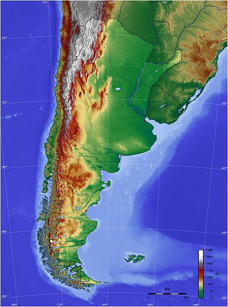
Español: Mapa de Argentina con su relieve
English: Map of Argentina with its terrain levels |
||||||||||
| Taariikhda | 9/06/2006 | ||||||||||
| Xigasho | See below | ||||||||||
| Qoraa | Captain Blood | ||||||||||
| Ogolaasho (Dib u isticmaalka faylkaan) |
|

Taariikhda faylka
Riix taariikhda/waqtiga si aad u argto faylka sida oo ahaa markiisa hore.
| Taariikhda/Waqtiga | Sawir yar | Cabirka | Isticmaale | Ka hadalka | |
|---|---|---|---|---|---|
| kan hadda | 21:45, 13 Mey 2009 | | 1,600 × 2,153 (565 KB) | Keysanger | reverted. (Deleted yellow line in the Straits of Magellan, added the definitive end of the controversial border at the Beagle Channel and marked with a white box the (last) undefined border zone as agreed both countries.) |
| 04:10, 5 Mey 2009 |  | 1,600 × 2,153 (867 KB) | Dexxter | Reverted to version as of 18:57, 9 June 2006 | |
| 20:13, 4 Juun 2008 |  | 1,600 × 2,153 (565 KB) | Keysanger | Argentina topo deleted yellow line in the Straits of Magellan, added the definitive end of the controversial border at the Beagle Channel and marked with a white box the (last) undefined border zone as agreed both countries. [[Category:[[Category:Topograp | |
| 18:57, 9 Juun 2006 |  | 1,600 × 2,153 (867 KB) | Captain Blood~commonswiki | {{Bild-GFDL-GMT}} |
Faylka lagu isticmaalay
Ma jiraan bogag adeegsanaya faylkaan.
isticmaalka faylka aduunka
Wikisyada kale ee soosocda ayaa adeegsanaya faylka:
- Ku isticmaal bg.wikipedia.org
- Ku isticmaal bn.wikipedia.org
- Ku isticmaal ca.wikipedia.org
- Ku isticmaal ckb.wikipedia.org
- Ku isticmaal dz.wikipedia.org
- Ku isticmaal ee.wikipedia.org
- Ku isticmaal el.wikipedia.org
- Ku isticmaal en.wikipedia.org
- Ku isticmaal eo.wikipedia.org
- Ku isticmaal es.wikipedia.org
- Ku isticmaal eu.wikipedia.org
- Ku isticmaal fa.wikipedia.org
- Ku isticmaal fi.wikipedia.org
- Ku isticmaal fr.wikipedia.org
- Ku isticmaal gcr.wikipedia.org
- Ku isticmaal hu.wikipedia.org
- Ku isticmaal hy.wikipedia.org
- Ku isticmaal incubator.wikimedia.org
- Ku isticmaal io.wikipedia.org
- Ku isticmaal it.wikipedia.org
- Ku isticmaal ja.wikipedia.org
- Ku isticmaal ka.wikipedia.org
- Ku isticmaal kbd.wikipedia.org
- Ku isticmaal ko.wikipedia.org
- Ku isticmaal ml.wikipedia.org
- Ku isticmaal ms.wikipedia.org
- Ku isticmaal mt.wikipedia.org
- Ku isticmaal pl.wikipedia.org
- Ku isticmaal pt.wikipedia.org
View more global usage of this file.