
File:Barringer Crater aerial photo by USGS.jpg

Cabirka muuqaalkaan: 800 × 535 pixels. Waxyaabaha kale xalinta: 320 × 214 pixels | 640 × 428 pixels | 1,024 × 685 pixels | 1,280 × 856 pixels | 2,400 × 1,605 pixels.
Faylka asalka ah (2,400 × 1,605 pixels, weyninka faylka : 3.25 MB, nuuca MIME: image/jpeg)
Qoraal kooban
| Sharaxaad |
Español: El origen de este cráter de impacto de meteorito simple y clásico fue durante mucho tiempo objeto de controversia. El descubrimiento de fragmentos del meteorito Cañón Diablo, incluidos fragmentos dentro de los depósitos de brechas que llenan parcialmente la estructura, y la presencia de una variedad de características metamórficas de choque en la arenisca objetivo, confirmaron el origen del impacto. Las rocas objetivo incluyen carbonatos paleozoicos y areniscas; estas rocas se han volcado justo fuera del borde durante la eyección. Los depósitos de montículos justo más allá del borde son restos de la capa de eyección. Esta vista aérea muestra la expresión dramática del cráter en el árido paisaje.
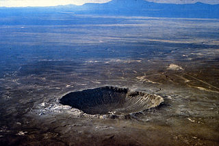
English: The origin of this classic, simple meteorite impact crater was long the subject of controversy. The discovery of fragments of the Canyon Diablo meteorite, including fragments within the breccia deposits that partially fill the structure, and the presence of a range of shock-metamorphic features in the target sandstone, confirmed its impact origin. Target rocks include Paleozoic carbonates and sandstones; these rocks have been overturned just outside the rim during ejection. The hummocky deposits just beyond the rim are remnants of the ejecta blanket. This aerial view shows the dramatic expression of the crater in the arid landscape.
العربية: فوهة بارينجر في ولاية أريزونا.أُحدثت منذ 50000 عام بواسطة مصادم حوالي 50 متر (160 قدم)، يظهر أن تنامي النظام الشمسي لم ينته بعد. |
| Xigasho | http://www.lpi.usra.edu/publications/slidesets/craters/slide_10.html / http://www.lpi.usra.edu/publications/slidesets/craters/images/10_METEOR_AERIAL.TIF |
| Qoraa | USGS/D. Roddy |
| Other versions |
Laysinka
This image is in the public domain in the United States because it only contains materials that originally came from the United States Geological Survey, an agency of the United States Department of the Interior. For more information, see the official USGS copyright policy.
|
Taariikhda faylka
Riix taariikhda/waqtiga si aad u argto faylka sida oo ahaa markiisa hore.
| Taariikhda/Waqtiga | Sawir yar | Cabirka | Isticmaale | Ka hadalka | |
|---|---|---|---|---|---|
| kan hadda | 01:55, 6 Febraayo 2015 | | 2,400 × 1,605 (3.25 MB) | Huntster | {{Information |Description={{en|1=The origin of this classic, simple meteorite impact crater was long the subject of controversy. The discovery of fragments of the Canyon Diablo meteorite, including fragments within the breccia deposits that partially... |
Faylka lagu isticmaalay
waxyaabaha soo socda ee bog ayaa adeegsanaya faylkaan:
isticmaalka faylka aduunka
Wikisyada kale ee soosocda ayaa adeegsanaya faylka:
- Ku isticmaal ar.wikipedia.org
- Ku isticmaal beta.wikiversity.org
- Ku isticmaal bg.wikipedia.org
- Ku isticmaal bn.wikipedia.org
- Ku isticmaal bs.wikipedia.org
- Ku isticmaal ckb.wikipedia.org
- Ku isticmaal da.wikipedia.org
- Ku isticmaal de.wikipedia.org
- Ku isticmaal el.wikipedia.org
- Ku isticmaal en.wikipedia.org
- Impact crater
- Age of Earth
- Meteor Crater
- Impact event
- National Natural Landmark
- User:Cyberherbalist
- Index of Arizona-related articles
- Formation and evolution of the Solar System
- User:Melicans
- User:Caprica
- User:AstroHurricane001/Userboxes
- User:StonedChipmunk/Userboxes
- User:Trilobitealive
- Portal:Solar System
- User:One Salient Oversight/Userboxes created
- User:Mat macwilliam
- User:Ryanho0001
- User:UBX/Impact Event
- User:Tyklink
- User:Beacon515L
- Wikipedia talk:WikiProject Userboxes/New Userboxes/Archive 7
- User:Sir Jimmy 07
- User:Speed and Sleep
- User:Rallyinspired
- User:Dark Lord Wiki
- User:Sapienyia
- Lead–lead dating
- User:Wiknerd/userboxes
- User:Sethiroth66/userboxes
- User:Hatewind
- User:The Genealogy Guy
- User:Xaremathras
- User:XubayrMA/Userboxes
View more global usage of this file.