
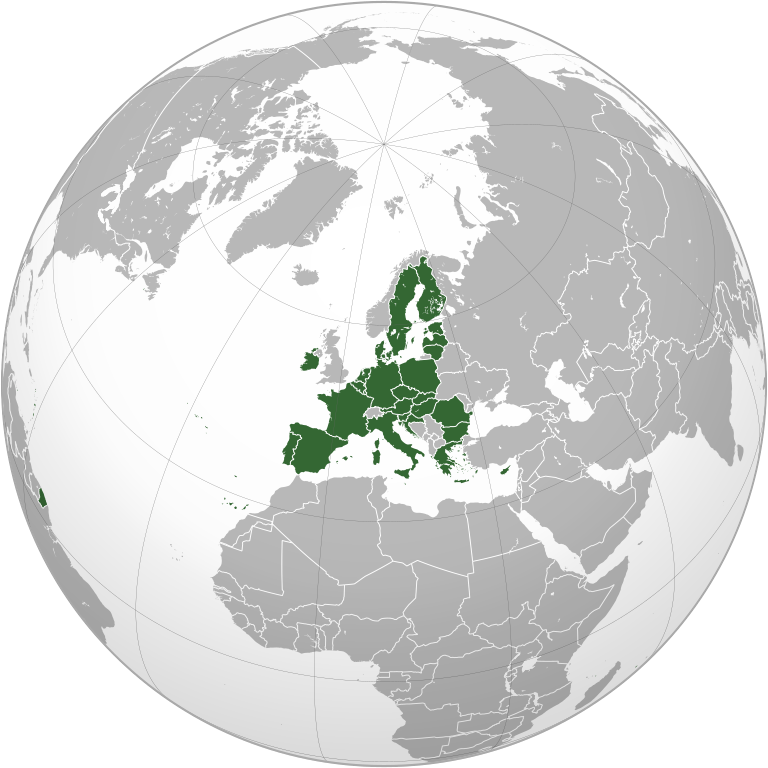
File:European Union (orthographic projection).svg

Size of this PNG preview of this SVG file: 600 × 600 pixels. Waxyaabaha kale xalinta: 240 × 240 pixels | 480 × 480 pixels | 768 × 768 pixels | 1,024 × 1,024 pixels | 2,048 × 2,048 pixels | 792 × 792 pixels.
Faylka asalka ah (SVG file, nominally 792 × 792 pixels, file size: 5.55 MB)
Qoraal kooban
| Sharaxaad |
|
||||
| Taariikhda | |||||
| Xigasho |
Own work,
|
||||
| Qoraa | Heraldry | ||||
| Ogolaasho (Dib u isticmaalka faylkaan) |
|
||||
| Other versions |
.svg) |
||||
| SVG genesis |

.svg)
.svg)
.svg)
.svg)
.svg)
.svg)
.svg)
.svg)
.svg)
.svg)
.svg)
.svg)
.svg)
.svg)
.svg)
.svg)
.svg)
.svg)
.svg)
.svg)
.svg)
.svg)
.svg)
.svg)
.svg)
.svg)
.svg)
.svg)
.svg)
.svg)
.svg)
.svg)
.svg)
.svg)
.svg)
.svg)
.svg)
.svg)
.svg)
.svg)
.svg)
.svg)
.svg)
.svg)
.svg)
.svg)
.svg)
.svg)
.svg)
.svg)
.svg)
.svg)
.svg)
.svg)
.svg)
.svg)
.svg)
.svg)
.svg)
.svg)
.svg)
.svg)
.svg)
.svg)
.svg)
.svg)
.svg)
.svg)
.svg)
.svg)
.svg)
.svg)
.svg)

.svg)

.svg)

.svg)
.svg)
.svg)
.svg)
.svg)
.svg)
.svg)


.svg)
.svg)
.svg)
.svg)
.svg)
.svg)
.svg)

.svg)
.svg)
.svg)
.svg)
.svg)
.svg)
.svg)
.svg)
.svg)
.svg)

.svg)
.svg)
.svg)
.svg)
.svg)
.svg)
.svg)
_without_national_boundaries.svg)
.svg)
.svg)
.svg)
.svg)
.svg)
.svg)

.svg)
.svg)
.png)
.svg)
.svg)
.svg)
.svg)

.svg)
.svg)
.svg)
.svg)
.svg)
.svg)
.svg)
.svg)
.svg)
.svg)
.svg)

.svg)
.svg)
.svg)
.svg)
.svg)
.svg)
.svg)
.svg)
.svg)

.svg)
.svg)

.svg)
.svg)
.svg)
.svg)
.svg)
.svg)
.svg)
.svg)
.svg)
.svg)
.svg)
.svg)
.svg)
.svg)
.svg)
.svg)
.svg)
.svg)
.svg)
.svg)
.svg)
.svg)
.svg)
.svg)
.svg)
.svg)
.svg)
_-_Crimea_disputed.svg)
.svg)
.svg)
.svg)
.svg)
.svg)
.svg)
.svg)
.svg)
.svg)
.svg)
.svg)
_political.svg)
.svg)
.svg)
.svg)
.svg)
_-_Crimea_disputed_-_no_borders.svg)
.svg)
.svg)
.svg)
.svg)
.svg)
.svg)
.svg)
.svg)
.svg)
.svg)
.svg)

.svg)
.svg)
.svg)

.png)
.svg)
.svg)
.svg)
.svg)
.svg)
.svg)
.svg)
.svg)
.svg)
.svg)
.svg)
.svg)
.svg)
.svg)
.svg)
.svg)
.svg)
.svg)
.svg)
.svg)
.svg)
.svg)
.svg)
.svg)
.svg)
.svg)
.svg)
.svg)
.svg)
.svg)
.svg)
.svg)
.svg)
.svg)
.png)
.svg)
.svg)
.svg)
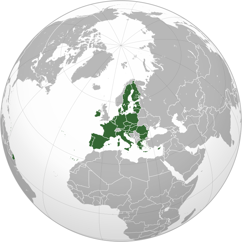
_(orthographic_projection).png)


.svg)
.svg)
.svg)
.svg)
.svg)
Laysinka
I, the copyright holder of this work, hereby publish it under the following license:

|
Permission is granted to copy, distribute and/or modify this document under the terms of the GNU Free Documentation License, Version 1.2 or any later version published by the Free Software Foundation; with no Invariant Sections, no Front-Cover Texts, and no Back-Cover Texts. A copy of the license is included in the section entitled GNU Free Documentation License. |
| This file is licensed under the Creative Commons Attribution-Share Alike 3.0 Unported license. | ||
| ||
| This licensing tag was added to this file as part of the GFDL licensing update. |
Taariikhda faylka
Riix taariikhda/waqtiga si aad u argto faylka sida oo ahaa markiisa hore.
| Taariikhda/Waqtiga | Sawir yar | Cabirka | Isticmaale | Ka hadalka | |
|---|---|---|---|---|---|
| kan hadda | 08:35, 2 Febraayo 2020 | | 792 × 792 (5.55 MB) | Rob984 | Fixed Flevoland in the Netherlands, removed Cyprus buffer zone, and general code cleanup (removing redundant groups etc.) |
| 01:59, 1 Febraayo 2020 |  | 792 × 792 (5.57 MB) | Rob984 | Restored Western Sahara-Morocco border removed 1 April 2018. | |
| 23:46, 31 Jannaayo 2020 |  | 792 × 792 (5.45 MB) | Rob984 | UK and Gibraltar have now left. | |
| 06:34, 1 Abriil 2018 |  | 792 × 792 (5.46 MB) | Giorgi Balakhadze | Correcting my mistake uploading other map | |
| 06:30, 1 Abriil 2018 |  | 537 × 536 (341 KB) | Giorgi Balakhadze | Per COM:OVERWRITE - the original file was without de-facto entities | |
| 23:33, 11 Luuliyo ama Luulyo 2014 |  | 792 × 792 (5.51 MB) | Rob984 | Improved version: More accurate coastline, borders, etc. Thicker borders. Centred on the centre of the mainland of the European Union. | |
| 02:51, 7 Sebteembar 2009 |  | 550 × 550 (508 KB) | TownDown | bigger | |
| 02:28, 7 Sebteembar 2009 |  | 450 × 450 (508 KB) | TownDown | {{Information |Description={{en|1=x}} |Source=Own work by uploader |Author=TownDown |Date= |Permission= |other_versions= }} Category:x |
Faylka lagu isticmaalay
Ma jiraan bogag adeegsanaya faylkaan.
isticmaalka faylka aduunka
Wikisyada kale ee soosocda ayaa adeegsanaya faylka:
- Ku isticmaal ar.wikipedia.org
- مركز الاتحاد الأوروبي للأقمار الصناعية
- انضمام تركيا إلى الاتحاد الأوروبي
- الشراكة الشرقية
- القوات المسلحة الفرنسية
- القوات المسلحة النمساوية
- القوات المسلحة السويدية
- الجيش المجري
- العلاقات الأردنية مع الاتحاد الأوروبي
- القوات المسلحة اليونانية
- غاليليو (نظام ملاحة)
- القوات المسلحة التشيكية
- القوات المسلحة الملكية الهولندية
- القوات المسلحة الليتوانية
- المجلس الأوروبي
- السياسة الأمنية والدفاعية المشتركة للاتحاد الأوروبي
- السياسة الخارجية والأمنية المشتركة للاتحاد الأوروبي
- القوات المسلحة الرومانية
- معاهدة بروكسل
- الشراكة بين المغرب والاتحاد الأوروبي
- علاقات فلسطين والاتحاد الأوروبي
- علاقات البحرين والاتحاد الأوروبي
- قائمة البعثات الدبلوماسية في بلجيكا
- الوكالة الأوروبية لحرس الحدود والسواحل
- الاتحاد الجمركي للاتحاد الأوروبي
- مجموعة دول إفريقيا والكاريبي والمحيط الهادئ
- اتفاقيات التجارة الحرة الأوروبية
- تاريخ علاقات الاتحاد الأوروبي - مع المملكة المتحدة
- الدائرة الأوروبية للشؤون الخارجية
- الممثل السامي للاتحاد للشؤون الخارجية والسياسة الأمنية
- العلاقات بين الولايات المتحدة والاتحاد الأوروبي
- يوروكوربس
- اتفاقية برلين بلس
- مجموعات القتال التابعة للاتحاد الأوروبي
- العلاقات بين الاتحاد الأوروبي وتركيا
- العلاقات بين أوكرانيا والاتحاد الأوروبي
- الممثل الخاص للاتحاد الأوروبي
- جماعة الدفاع الأوروبية
- العلاقات بين إندونيسيا والاتحاد الأوروبي
- تمرين فيريتي
- الاتحاد الغربي
- العلاقات بين كندا والاتحاد الأوروبي
- إعلان سان مالو
- هدف هلسنكي الرئيسي
- العلاقات بين آيسلندا والاتحاد الأوروبي
- العلاقات بين سان مارينو والاتحاد الأوروبي
- العلاقات المصرية مع الاتحاد الأوروبي
- انضمام الجبل الأسود إلى الاتحاد الأوروبي
- جرينلاند والاتحاد الأوروبي
- علم الاتحاد الغربي
- علم اتحاد أوروبا الغربية
View more global usage of this file.
.svg)
.svg)