
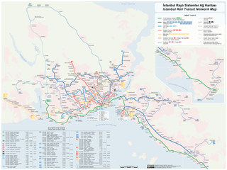
File:Istanbul Rapid Transit Map.png

Cabirka muuqaalkaan: 800 × 600 pixels. Waxyaabaha kale xalinta: 320 × 240 pixels | 640 × 480 pixels | 1,024 × 768 pixels | 1,280 × 960 pixels | 2,560 × 1,919 pixels | 4,159 × 3,118 pixels.
Faylka asalka ah (4,159 × 3,118 pixels, weyninka faylka : 2.02 MB, nuuca MIME: image/png)

|
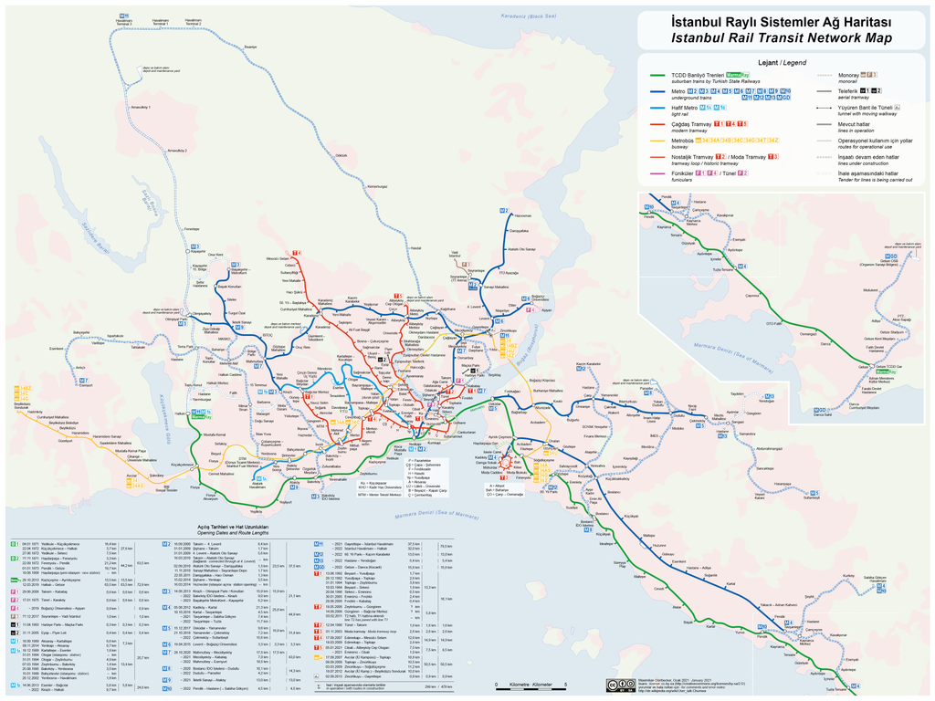
File:Istanbul Railway Systems Network Map.svg is a vector version of this file. It should be used in place of this PNG file when not inferior.
File:Istanbul Rapid Transit Map.png → File:Istanbul Railway Systems Network Map.svg
For more information, see Help:SVG. |
 |
Need Assistance!
I don't live in Turkey and the map basically was drawn after some informations from the Web which are often incorrect or very inaccurate. So if you want the network map as accurate as possible too, please announce your error hints and corrections on my German discussion page.
Thank you in advance!

|
This transport map image could be re-created using vector graphics as an SVG file. This has several advantages; see Commons:Media for cleanup for more information. If an SVG form of this image is available, please upload it and afterwards replace this template with
{{vector version available|new image name}}.
It is recommended to name the SVG file “Istanbul Rapid Transit Map.svg”—then the template Vector version available (or Vva) does not need the new image name parameter. |
| Sharaxaad |
|
|||
| Taariikhda | see file history | |||
| Xigasho | Shaqadayda | |||
| Qoraa | Maximilian Dörrbecker (Chumwa) | |||
| Ogolaasho (Dib u isticmaalka faylkaan) |
I, the copyright holder of this work, hereby publish it under the following license: This file is licensed under the Creative Commons Attribution-Share Alike 2.5 Generic license.
Sie dürfen das Bild zu den folgenden Bedingungen nutzen:
|
|||
| Other versions |
Current maps:
Older maps (not longer maintained):
|

.png)


.png)
.png)
Taariikhda faylka
Riix taariikhda/waqtiga si aad u argto faylka sida oo ahaa markiisa hore.
| Taariikhda/Waqtiga | Sawir yar | Cabirka | Isticmaale | Ka hadalka | |
|---|---|---|---|---|---|
| kan hadda | 06:31, 3 Jannaayo 2021 | | 4,159 × 3,118 (2.02 MB) | Chumwa | update |
| 08:59, 7 Nofeembar 2020 |  | 4,159 × 3,118 (2 MB) | Chumwa | update | |
| 07:57, 13 Juun 2020 |  | 4,159 × 3,118 (2.03 MB) | Chumwa | update | |
| 19:34, 1 Abriil 2019 |  | 3,993 × 3,118 (1.99 MB) | Chumwa | ||
| 19:05, 31 Maaj 2019 |  | 3,993 × 3,118 (1.98 MB) | Chumwa | corr | |
| 17:33, 31 Maaj 2019 |  | 3,993 × 3,118 (1.97 MB) | Chumwa | update | |
| 20:39, 14 Maaj 2019 |  | 3,993 × 2,311 (1.79 MB) | Chumwa | update | |
| 20:46, 30 Oktoobar 2018 |  | 3,993 × 2,311 (1.85 MB) | Chumwa | update | |
| 17:36, 26 Luuliyo ama Luulyo 2018 |  | 3,993 × 2,311 (1.86 MB) | Chumwa | update | |
| 08:02, 8 Luuliyo ama Luulyo 2018 |  | 3,993 × 2,311 (1.82 MB) | Chumwa | update |
Faylka lagu isticmaalay
Ma jiraan bogag adeegsanaya faylkaan.
isticmaalka faylka aduunka
Wikisyada kale ee soosocda ayaa adeegsanaya faylka:
- Ku isticmaal ca.wikipedia.org
- Ku isticmaal de.wikipedia.org
- Benutzer:Chumwa
- Diskussion:Marmaray
- Benutzer Diskussion:Chumwa/Archiv/2010/1. Quartal
- Benutzer Diskussion:Chumwa/Archiv/2011/1. Quartal
- Wikipedia:Kartenwerkstatt/Karte des Tages/Galerie
- Benutzer:Chumwa/SomeOfMyFiles
- Benutzer Diskussion:Chumwa/Archiv/2016/2. Quartal
- Benutzer Diskussion:Chumwa/Archiv/2016/4. Quartal
- Benutzer Diskussion:Chumwa/Archiv/2017/2. Quartal
- Benutzer Diskussion:Chumwa/Archiv/2020/4. Quartal
- Benutzer Diskussion:Chumwa/Archiv/2022/4. Quartal
- Ku isticmaal en.wikipedia.org
- Ku isticmaal fr.wikipedia.org
- Ku isticmaal ru.wikipedia.org
- Тюнель
- Стамбульский трамвай
- Мармарай
- Стамбульский метрополитен
- Общественный транспорт Стамбула
- Линия 2 (Стамбульский метрополитен)
- Линия 3 (Стамбульский метрополитен)
- Линия 6 (Стамбульский метрополитен)
- Линия 1 (Стамбульский метрополитен)
- Линия 5 (Стамбульский метрополитен)
- Линия 4 (Стамбульский метрополитен)
- İstanbul Deniz Otobüsleri
- Istanbulkart
- Фуникулёр Кабаташ—Таксим
- Эюп (канатная дорога)
- Мачка (канатная дорога)
- Линия 7 (Стамбульский метрополитен)
- Линия 8 (Стамбульский метрополитен)
- Линия 9 (Стамбульский метрополитен)
- Шаблон:Общественный транспорт Стамбула
- Metro Istanbul