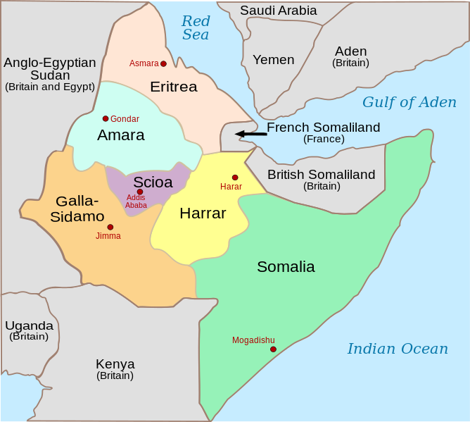
File:Italian East Africa (1938–1941).svg

Size of this PNG preview of this SVG file: 668 × 599 pixels. Waxyaabaha kale xalinta: 268 × 240 pixels | 535 × 480 pixels | 856 × 768 pixels | 1,141 × 1,024 pixels | 2,283 × 2,048 pixels | 1,012 × 908 pixels.
Faylka asalka ah (SVG file, nominally 1,012 × 908 pixels, file size: 90 KB)
Taariikhda faylka
Riix taariikhda/waqtiga si aad u argto faylka sida oo ahaa markiisa hore.
| Taariikhda/Waqtiga | Sawir yar | Cabirka | Isticmaale | Ka hadalka | |
|---|---|---|---|---|---|
| kan hadda | 01:02, 27 Diseembar 2023 |  | 1,012 × 908 (90 KB) | 123taro | File uploaded using svgtranslate tool (https://svgtranslate.toolforge.org/). Added translation for ja. |
| 08:50, 5 Oktoobar 2023 |  | 1,012 × 908 (84 KB) | Amortres | File uploaded using svgtranslate tool (https://svgtranslate.toolforge.org/). Added translation for ca. | |
| 08:47, 5 Oktoobar 2023 |  | 1,012 × 908 (84 KB) | Amortres | File uploaded using svgtranslate tool (https://svgtranslate.toolforge.org/). Added translation for ca. | |
| 19:58, 16 Agoosto 2018 |  | 1,012 × 908 (73 KB) | Hohum | Better focus on subject, cartographic colours | |
| 20:39, 16 Nofeembar 2008 |  | 1,012 × 908 (74 KB) | Themightyquill | ||
| 17:47, 14 Nofeembar 2008 |  | 1,012 × 908 (75 KB) | Themightyquill | ||
| 15:20, 17 Juun 2008 |  | 1,012 × 908 (74 KB) | Themightyquill | ||
| 15:14, 17 Juun 2008 |  | 1,012 × 908 (66 KB) | Themightyquill | {{Information |Description={{en|Italian East Africa, with provinces and provincial capitals, between May 7, 1936 (Annexation of Ethiopia) and August 1940 (when Italy invaded and annexed [[:en |
Faylka lagu isticmaalay
waxyaabaha soo socda ee bog ayaa adeegsanaya faylkaan:
isticmaalka faylka aduunka
Wikisyada kale ee soosocda ayaa adeegsanaya faylka:
- Ku isticmaal azb.wikipedia.org
- Ku isticmaal bg.wikipedia.org
- Ku isticmaal bs.wikipedia.org
- Ku isticmaal ca.wikipedia.org
- Ku isticmaal da.wikipedia.org
- Ku isticmaal de.wikipedia.org
- Ku isticmaal en.wikipedia.org
- Italian East Africa
- Second Italo-Ethiopian War
- Gideon Force
- East African campaign (World War II)
- List of national border changes (1914–present)
- Battle of Keren
- Italian invasion of British Somaliland
- Governorates of Italian East Africa
- Harar Governorate
- Amhara Governorate
- Galla-Sidamo Governorate
- Somalia Governorate
- Italians of Ethiopia
- Italian Ethiopia
- Southern Rhodesia in World War II
- Scioa Governorate
- Northern front, East Africa, 1940
- User talk:Isayas Legese
- List of governors of the governorates of Italian East Africa
- 23 Field Regiment (India)
- Territorial evolution of Ethiopia
- Ku isticmaal en.wikibooks.org
- Ku isticmaal es.wikipedia.org
- Ku isticmaal et.wikipedia.org
- Ku isticmaal eu.wikipedia.org
- Ku isticmaal fa.wikipedia.org
- Ku isticmaal fi.wikipedia.org
- Ku isticmaal he.wikipedia.org
- Ku isticmaal incubator.wikimedia.org
- Ku isticmaal it.wikipedia.org
- Ku isticmaal ja.wikipedia.org
- Ku isticmaal lt.wikipedia.org
View more global usage of this file.


