
File:Koppen-Geiger Map ARG present.svg

Size of this PNG preview of this SVG file: 512 × 423 pixels. Waxyaabaha kale xalinta: 291 × 240 pixels | 581 × 480 pixels | 930 × 768 pixels | 1,240 × 1,024 pixels | 2,479 × 2,048 pixels.
Faylka asalka ah (SVG file, nominally 512 × 423 pixels, file size: 1.21 MB)
Qoraal kooban
| Sharaxaad |
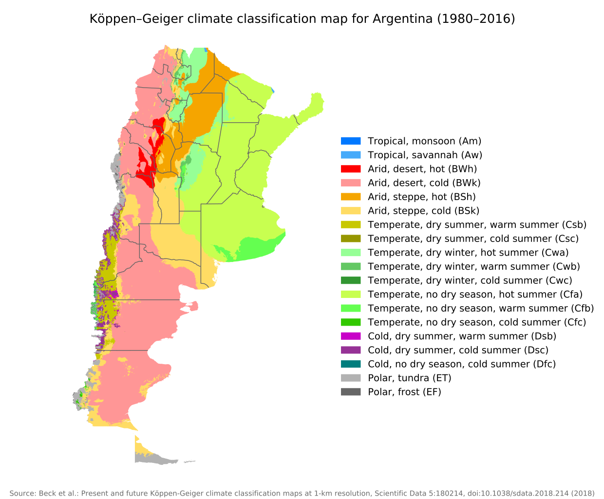
English: Köppen–Geiger climate classification map for Argentina |
| Taariikhda | |
| Xigasho | "Present and future Köppen-Geiger climate classification maps at 1-km resolution". Nature Scientific Data. DOI:10.1038/sdata.2018.214. |
| Qoraa | Beck, H.E., Zimmermann, N. E., McVicar, T. R., Vergopolan, N., Berg, A., & Wood, E. F. |
Laysinka
This file is licensed under the Creative Commons Attribution 4.0 International license.
- Waad fasaxantahay:
- la wadaagid – koobi gareenta, qaybinta iyo gudbinta shaqada
- to remix – in shaqada la waafajiyo
- Shuruudaha soo socda:
- Astaan – You must give appropriate credit, provide a link to the license, and indicate if changes were made. You may do so in any reasonable manner, but not in any way that suggests the licensor endorses you or your use.
| Camera location | | View this and other nearby images on: OpenStreetMap |
|---|
Taariikhda faylka
Riix taariikhda/waqtiga si aad u argto faylka sida oo ahaa markiisa hore.
| Taariikhda/Waqtiga | Sawir yar | Cabirka | Isticmaale | Ka hadalka | |
|---|---|---|---|---|---|
| kan hadda | 09:14, 8 Sebteembar 2020 | | 512 × 423 (1.21 MB) | Allice Hunter | Provinces and adjustments |
| 15:44, 17 Luuliyo ama Luulyo 2020 |  | 1,208 × 850 (1.51 MB) | JPLema | Reverted to version as of 21:36, 15 June 2020 (UTC) | |
| 15:43, 17 Luuliyo ama Luulyo 2020 |  | 840 × 812 (1.45 MB) | JPLema | reducción de tamaño | |
| 21:36, 15 Juun 2020 |  | 1,208 × 850 (1.51 MB) | JPLema | Reverted to version as of 03:03, 26 November 2018 (UTC) | |
| 13:02, 15 Juun 2020 |  | 696 × 1,006 (1.34 MB) | JPLema | reduje el ancho y aumenté la altura | |
| 03:03, 26 Nofeembar 2018 |  | 1,208 × 850 (1.51 MB) | NVergopolan | {{Information |Description={{en| Köppen–Geiger climate classification map for Argentina}}|date=2018-11-06|source={{cite journal | journal=Nature Scientific Data |doi=10.1038/sdata.2018.214}}|author=Beck, H.E., Zimmermann, N. E., McVicar, T. R., Vergopolan, N., Berg, A., & Wood, E. F.|permission=|other_versions=|other_fields=}}{{Cc-by-4.0}}{{Location|-38.42003918|-63.58480835}}Category:Köppen-Geiger Climate Classification MapsCategory:present climate (1980–2016)Category:Argentina[[... |
Faylka lagu isticmaalay
Ma jiraan bogag adeegsanaya faylkaan.
isticmaalka faylka aduunka
Wikisyada kale ee soosocda ayaa adeegsanaya faylka:
- Ku isticmaal bg.wikipedia.org
- Ku isticmaal ckb.wikipedia.org
- Ku isticmaal en.wikipedia.org
- Ku isticmaal id.wikipedia.org
- Ku isticmaal ja.wikipedia.org
- Ku isticmaal km.wikipedia.org
- Ku isticmaal pt.wikipedia.org
- Ku isticmaal ru.wikipedia.org
- Ku isticmaal sr.wikipedia.org
- Ku isticmaal tr.wikipedia.org
- Ku isticmaal uk.wikipedia.org