
File:Somaliland Italian invasion.png
Cabirka muuqaalkaan: 800 × 505 pixels. Waxyaabaha kale xalinta: 320 × 202 pixels | 640 × 404 pixels | 1,024 × 647 pixels | 1,280 × 808 pixels | 2,965 × 1,872 pixels.
Faylka asalka ah (2,965 × 1,872 pixels, weyninka faylka : 6.11 MB, nuuca MIME: image/png)
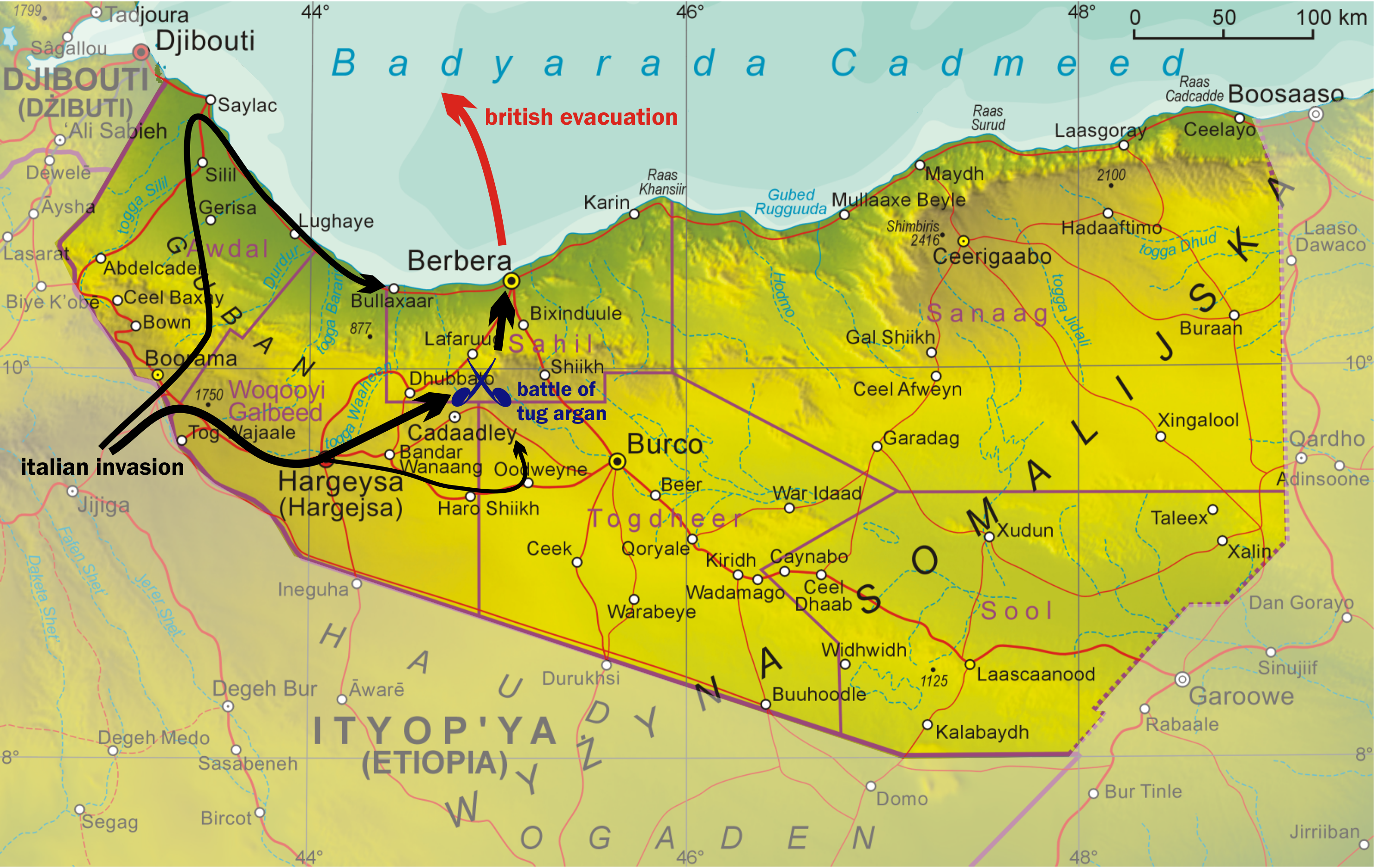
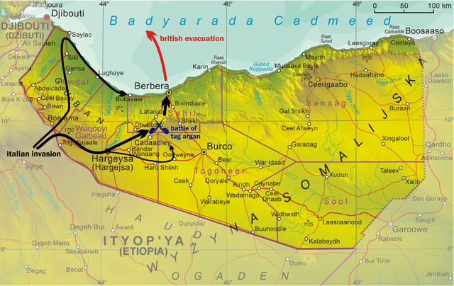
| Sharaxaad | Map of the Italian invasion of British Somaliland. Meant to replace w:File:Italian_Invasion_British_Somaliland.JPG. |
| Taariikhda | (UTC) |
| Xigasho | |
| Qoraa |
|
I, the copyright holder of this work, hereby publish it under the following license:

|
Permission is granted to copy, distribute and/or modify this document under the terms of the GNU Free Documentation License, Version 1.2 or any later version published by the Free Software Foundation; with no Invariant Sections, no Front-Cover Texts, and no Back-Cover Texts. A copy of the license is included in the section entitled GNU Free Documentation License. |
| This file is licensed under the Creative Commons Attribution-Share Alike 3.0 Unported license. | ||
| ||
| This licensing tag was added to this file as part of the GFDL licensing update. |
Original upload log
This image is a derivative work of the following images:
- File:Somaliland.png licensed with GFDL
- 2008-11-01T08:20:40Z Aotearoa 1815x1143 (2728478 Bytes) {{Information |Description= |Source= |Date= |Author= |Permission= |other_versions= }}
- 2008-10-12T08:55:38Z Aotearoa 1360x854 (1727437 Bytes) {{Information |Description={{en|1=Map of Somaliland}} {{pl|1=Mapa Somalilandu}} |Source=Praca własna osoby przesyłającej (own work by uploader) |Author=[[User:Aotearoa|Aotearoa]] |Date=12.10.2008 |Permission= |other_versio
Uploaded with derivativeFX
Taariikhda faylka
Riix taariikhda/waqtiga si aad u argto faylka sida oo ahaa markiisa hore.
| Taariikhda/Waqtiga | Sawir yar | Cabirka | Isticmaale | Ka hadalka | |
|---|---|---|---|---|---|
| kan hadda | 08:43, 9 Luuliyo ama Luulyo 2009 | | 2,965 × 1,872 (6.11 MB) | Classical geographer | Something went wrong last time. |
| 08:40, 9 Luuliyo ama Luulyo 2009 |  | 3,706 × 2,339 (34 KB) | Classical geographer | Made non-Somaliland areas lighter. | |
| 22:20, 8 Luuliyo ama Luulyo 2009 |  | 2,224 × 1,404 (4 MB) | Classical geographer | {{Information |Description=Map of the Italian invasion of British Somaliland. Meant to replace w:File:Italian_Invasion_British_Somaliland.JPG. |Source=*File:Somaliland.png |Date=2009-07-08 21:49 (UTC) |Author=*File:Somaliland.png: [[User: |
Faylka lagu isticmaalay
waxyaabaha soo socda ee bog ayaa adeegsanaya faylkaan:
isticmaalka faylka aduunka
Wikisyada kale ee soosocda ayaa adeegsanaya faylka:
- Ku isticmaal als.wikipedia.org
- Ku isticmaal ar.wikipedia.org
- Ku isticmaal bg.wikipedia.org
- Ku isticmaal bs.wikipedia.org
- Ku isticmaal cs.wikipedia.org
- Ku isticmaal da.wikipedia.org
- Ku isticmaal de.wikipedia.org
- Ku isticmaal en.wikipedia.org
- Ku isticmaal fa.wikipedia.org
- Ku isticmaal fi.wikipedia.org
- Ku isticmaal fr.wikipedia.org
- Ku isticmaal id.wikipedia.org
- Ku isticmaal it.wikipedia.org
- Ku isticmaal ja.wikipedia.org
- Ku isticmaal ko.wikipedia.org
- Ku isticmaal pl.wikipedia.org
- Ku isticmaal ru.wikipedia.org
- Ku isticmaal sr.wikipedia.org
- Ku isticmaal ta.wikipedia.org
- Ku isticmaal th.wikipedia.org
- Ku isticmaal tr.wikipedia.org
- Ku isticmaal uk.wikipedia.org
- Ku isticmaal vi.wikipedia.org
- Ku isticmaal www.wikidata.org
- Ku isticmaal zh.wikipedia.org