
File:Spice Islands (Zanzibar highlighted).svg

Size of this PNG preview of this SVG file: 486 × 599 pixels. Waxyaabaha kale xalinta: 195 × 240 pixels | 389 × 480 pixels | 623 × 768 pixels | 831 × 1,024 pixels | 1,662 × 2,048 pixels | 512 × 631 pixels.
Faylka asalka ah (SVG file, nominally 512 × 631 pixels, file size: 6.08 MB)
.svg)
Qoraal kooban
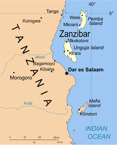
| Sharaxaad | Part of the map of Tanzania, showing the Spice Islands, and highlighting Zanzibar. |
| Taariikhda | |
| Xigasho | Vectors self-made in Inkscape. Source was cropped from 2003 Political map of Tanzania at Perry-Castañeda Library Map Collection — Tanzania. The maps are attributed to the US Central Intelligence Agency. |
| Qoraa | Mysid |
| Other versions |
Derivative works of this file: Image:Spice Islands (Tanzania).svgin French : Image:Spice_Islands_Tanzania-fr.svg in French : Image:Spice_Islands-Zanzibar_highlighted-fr.svg in Arabic: Image:Spice Islands (Zanzibar highlighted)-ar.svg |
| SVG genesis |
_el.svg)
_sv.svg)
.svg)
-ar.svg)
Laysinka
| I, the copyright holder of this work, release this work into the public domain. This applies worldwide. In some countries this may not be legally possible; if so: I grant anyone the right to use this work for any purpose, without any conditions, unless such conditions are required by law. |
Taariikhda faylka
Riix taariikhda/waqtiga si aad u argto faylka sida oo ahaa markiisa hore.
| Taariikhda/Waqtiga | Sawir yar | Cabirka | Isticmaale | Ka hadalka | |
|---|---|---|---|---|---|
| kan hadda | 02:16, 9 Oktoobar 2021 | | 512 × 631 (6.08 MB) | Nwbeeson | Zanzibar Island renamed to Unguja Island to match article caption |
| 20:09, 6 Jannaayo 2007 |  | 713 × 879 (15 KB) | Mysid | higlighting Pemba as well | |
| 20:06, 6 Jannaayo 2007 |  | 713 × 879 (15 KB) | Mysid | == Summary == {{Information |Description=Part of the map of Tanzania, showing the Spice Islands, and highlighting Zanzibar. |Source=Vectors self-made in Inkscape. Source was cropped from http://www.lib.utexas.edu/maps/africa/tanzania_p |
Faylka lagu isticmaalay
Ma jiraan bogag adeegsanaya faylkaan.
isticmaalka faylka aduunka
Wikisyada kale ee soosocda ayaa adeegsanaya faylka:
- Ku isticmaal af.wikipedia.org
- Ku isticmaal ar.wikipedia.org
- Ku isticmaal ast.wikipedia.org
- Ku isticmaal ast.wiktionary.org
- Ku isticmaal azb.wikipedia.org
- Ku isticmaal az.wikipedia.org
- Ku isticmaal ba.wikipedia.org
- Ku isticmaal bg.wikipedia.org
- Ku isticmaal bn.wikipedia.org
- Ku isticmaal br.wikipedia.org
- Ku isticmaal ca.wikipedia.org
- Ku isticmaal cs.wikipedia.org
- Ku isticmaal de.wikipedia.org
- Ku isticmaal en.wikipedia.org
- Ku isticmaal eo.wikipedia.org
- Ku isticmaal eu.wikipedia.org
- Ku isticmaal fa.wikipedia.org
- Ku isticmaal fiu-vro.wikipedia.org
- Ku isticmaal fr.wikipedia.org
- Ku isticmaal gd.wikipedia.org
- Ku isticmaal gl.wikipedia.org
- Ku isticmaal ha.wikipedia.org
- Ku isticmaal hr.wikipedia.org
- Ku isticmaal hy.wikipedia.org
- Ku isticmaal id.wikipedia.org
- Ku isticmaal it.wikipedia.org
- Ku isticmaal it.wikivoyage.org
- Ku isticmaal ja.wikipedia.org
- Ku isticmaal ka.wikipedia.org
- Ku isticmaal ko.wikipedia.org
- Ku isticmaal ku.wikipedia.org
- Ku isticmaal lt.wikipedia.org
- Ku isticmaal lv.wikipedia.org
- Ku isticmaal mg.wikipedia.org
- Ku isticmaal nl.wikipedia.org
View more global usage of this file.
.svg)
.svg)